You are here: Home > Network List > TA - USArray Transportable Network (new EarthScope stations) Stations List
> Station S24A Houchin Ranch, La Veta, CO, USA > Earthquake Result Viewer
S24A Houchin Ranch, La Veta, CO, USA - Earthquake Result Viewer
| Earthquake location: |
Tonga Islands Region |
| Earthquake latitude/longitude: |
-23.0/-174.7 |
| Earthquake time(UTC): |
2009/03/19 (078) 18:17:40 GMT |
| Earthquake Depth: |
34 km |
| Earthquake Magnitude: |
7.0 MB, 7.6 MS, 7.6 MW, 7.6 MW |
| Earthquake Catalog/Contributor: |
WHDF/NEIC |
|
| Network: |
TA USArray Transportable Network (new EarthScope stations) |
| Station: |
S24A Houchin Ranch, La Veta, CO, USA |
| Lat/Lon: |
37.64 N/105.21 W |
| Elevation: |
2672 m |
|
| Distance: |
88.9 deg |
| Az: |
48.026 deg |
| Baz: |
239.618 deg |
| Ray Param: |
0.04223304 |
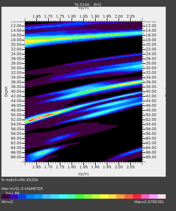
| Estimated Moho Depth: |
51.0 km |
| Estimated Crust Vp/Vs: |
1.66 |
| Assumed Crust Vp: |
6.316 km/s |
| Estimated Crust Vs: |
3.805 km/s |
| Estimated Crust Poisson's Ratio: |
0.22 |
|
| Radial Match: |
98.45206 % |
| Radial Bump: |
321 |
| Transverse Match: |
92.42034 % |
| Transverse Bump: |
400 |
| SOD ConfigId: |
2658 |
| Insert Time: |
2010-03-06 13:57:07.143 +0000 |
| GWidth: |
2.5 |
| Max Bumps: |
400 |
| Tol: |
0.001 |
|

Signal To Noise
| Channel | StoN | STA | LTA |
| TA:S24A: :BHZ:20090319T18:30:00.324001Z | 19.437546 | 4.8296324E-6 | 2.4846923E-7 |
| TA:S24A: :BHN:20090319T18:30:00.324001Z | 4.397582 | 4.973038E-7 | 1.1308574E-7 |
| TA:S24A: :BHE:20090319T18:30:00.324001Z | 8.72068 | 1.0675635E-6 | 1.2241746E-7 |
| Arrivals |
| Ps | 5.4 SECOND |
| PpPs | 21 SECOND |
| PsPs/PpSs | 26 SECOND |


