You are here: Home > Network List > TA - USArray Transportable Network (new EarthScope stations) Stations List
> Station M18K Stony River, AK, USA > Earthquake Result Viewer
M18K Stony River, AK, USA - Earthquake Result Viewer
| Earthquake location: |
Volcano Islands, Japan Region |
| Earthquake latitude/longitude: |
23.4/143.4 |
| Earthquake time(UTC): |
2018/08/16 (228) 18:21:31 GMT |
| Earthquake Depth: |
12 km |
| Earthquake Magnitude: |
5.8 Mwb |
| Earthquake Catalog/Contributor: |
NEIC PDE/us |
|
| Network: |
TA USArray Transportable Network (new EarthScope stations) |
| Station: |
M18K Stony River, AK, USA |
| Lat/Lon: |
61.49 N/155.82 W |
| Elevation: |
289 m |
|
| Distance: |
55.9 deg |
| Az: |
30.396 deg |
| Baz: |
255.736 deg |
| Ray Param: |
0.0645004 |
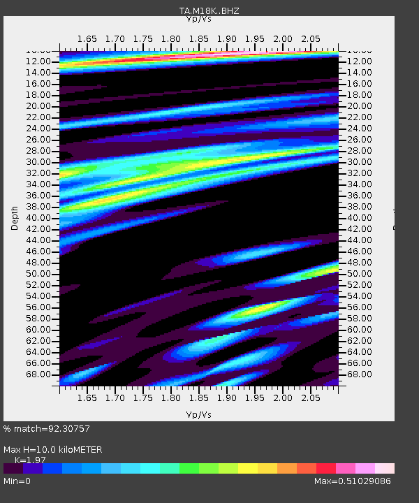
| Estimated Moho Depth: |
10.0 km |
| Estimated Crust Vp/Vs: |
1.97 |
| Assumed Crust Vp: |
6.566 km/s |
| Estimated Crust Vs: |
3.333 km/s |
| Estimated Crust Poisson's Ratio: |
0.33 |
|
| Radial Match: |
92.30757 % |
| Radial Bump: |
290 |
| Transverse Match: |
78.36503 % |
| Transverse Bump: |
400 |
| SOD ConfigId: |
13570011 |
| Insert Time: |
2019-04-30 19:48:24.476 +0000 |
| GWidth: |
2.5 |
| Max Bumps: |
400 |
| Tol: |
0.001 |
|

Signal To Noise
| Channel | StoN | STA | LTA |
| TA:M18K: :BHZ:20180816T18:30:37.424973Z | 2.4466712 | 1.8852926E-7 | 7.705541E-8 |
| TA:M18K: :BHN:20180816T18:30:37.424973Z | 0.9491144 | 7.5007456E-8 | 7.9028894E-8 |
| TA:M18K: :BHE:20180816T18:30:37.424973Z | 1.2195519 | 6.261471E-8 | 5.134239E-8 |
| Arrivals |
| Ps | 1.6 SECOND |
| PpPs | 4.3 SECOND |
| PsPs/PpSs | 5.9 SECOND |


