You are here: Home > Network List > TA - USArray Transportable Network (new EarthScope stations) Stations List
> Station O17K Koliganek, Bristol Bay, AK, USA > Earthquake Result Viewer
O17K Koliganek, Bristol Bay, AK, USA - Earthquake Result Viewer
| Earthquake location: |
Volcano Islands, Japan Region |
| Earthquake latitude/longitude: |
23.4/143.4 |
| Earthquake time(UTC): |
2018/08/16 (228) 18:21:31 GMT |
| Earthquake Depth: |
12 km |
| Earthquake Magnitude: |
5.8 Mwb |
| Earthquake Catalog/Contributor: |
NEIC PDE/us |
|
| Network: |
TA USArray Transportable Network (new EarthScope stations) |
| Station: |
O17K Koliganek, Bristol Bay, AK, USA |
| Lat/Lon: |
59.77 N/157.09 W |
| Elevation: |
156 m |
|
| Distance: |
54.8 deg |
| Az: |
32.238 deg |
| Baz: |
255.677 deg |
| Ray Param: |
0.065180786 |
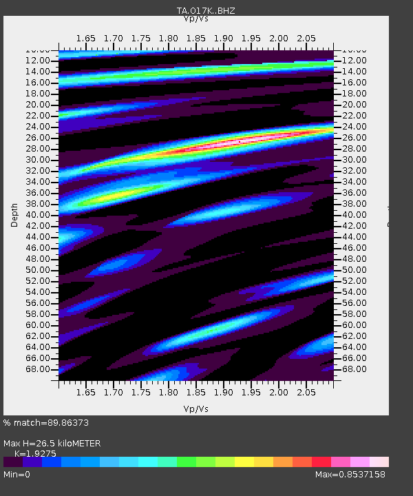
| Estimated Moho Depth: |
26.5 km |
| Estimated Crust Vp/Vs: |
1.93 |
| Assumed Crust Vp: |
6.276 km/s |
| Estimated Crust Vs: |
3.256 km/s |
| Estimated Crust Poisson's Ratio: |
0.32 |
|
| Radial Match: |
89.86373 % |
| Radial Bump: |
302 |
| Transverse Match: |
74.30596 % |
| Transverse Bump: |
400 |
| SOD ConfigId: |
13570011 |
| Insert Time: |
2019-04-30 19:48:32.675 +0000 |
| GWidth: |
2.5 |
| Max Bumps: |
400 |
| Tol: |
0.001 |
|
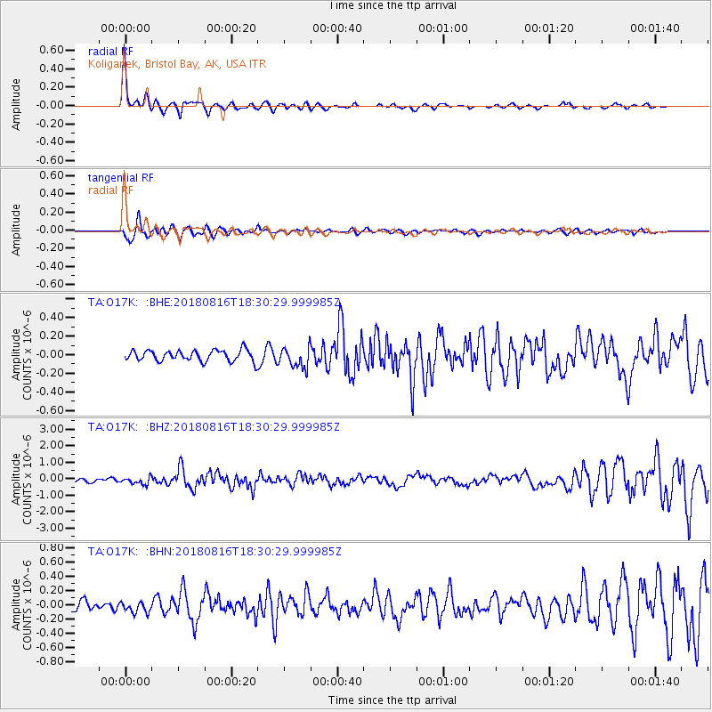
Signal To Noise
| Channel | StoN | STA | LTA |
| TA:O17K: :BHZ:20180816T18:30:29.999985Z | 2.593819 | 2.1299637E-7 | 8.2116905E-8 |
| TA:O17K: :BHN:20180816T18:30:29.999985Z | 1.1283867 | 7.5799804E-8 | 6.7175385E-8 |
| TA:O17K: :BHE:20180816T18:30:29.999985Z | 1.850386 | 1.1134635E-7 | 6.0174656E-8 |
| Arrivals |
| Ps | 4.1 SECOND |
| PpPs | 12 SECOND |
| PsPs/PpSs | 16 SECOND |


