You are here: Home > Network List > TA - USArray Transportable Network (new EarthScope stations) Stations List
> Station P18K Big Mountain, AK, USA > Earthquake Result Viewer
P18K Big Mountain, AK, USA - Earthquake Result Viewer
| Earthquake location: |
Volcano Islands, Japan Region |
| Earthquake latitude/longitude: |
23.4/143.4 |
| Earthquake time(UTC): |
2018/08/16 (228) 18:21:31 GMT |
| Earthquake Depth: |
12 km |
| Earthquake Magnitude: |
5.8 Mwb |
| Earthquake Catalog/Contributor: |
NEIC PDE/us |
|
| Network: |
TA USArray Transportable Network (new EarthScope stations) |
| Station: |
P18K Big Mountain, AK, USA |
| Lat/Lon: |
59.39 N/155.23 W |
| Elevation: |
680 m |
|
| Distance: |
55.7 deg |
| Az: |
32.956 deg |
| Baz: |
257.692 deg |
| Ray Param: |
0.064628564 |
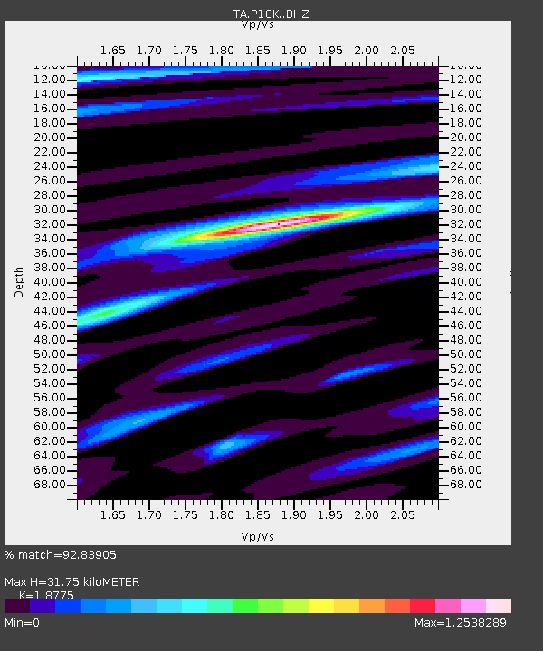
| Estimated Moho Depth: |
31.75 km |
| Estimated Crust Vp/Vs: |
1.88 |
| Assumed Crust Vp: |
6.438 km/s |
| Estimated Crust Vs: |
3.429 km/s |
| Estimated Crust Poisson's Ratio: |
0.30 |
|
| Radial Match: |
92.83905 % |
| Radial Bump: |
281 |
| Transverse Match: |
78.29477 % |
| Transverse Bump: |
400 |
| SOD ConfigId: |
13570011 |
| Insert Time: |
2019-04-30 19:48:36.524 +0000 |
| GWidth: |
2.5 |
| Max Bumps: |
400 |
| Tol: |
0.001 |
|

Signal To Noise
| Channel | StoN | STA | LTA |
| TA:P18K: :BHZ:20180816T18:30:35.999985Z | 3.2588203 | 1.8450643E-7 | 5.6617555E-8 |
| TA:P18K: :BHN:20180816T18:30:35.999985Z | 1.0196416 | 6.5102476E-8 | 6.384838E-8 |
| TA:P18K: :BHE:20180816T18:30:35.999985Z | 1.8321935 | 1.1182587E-7 | 6.103387E-8 |
| Arrivals |
| Ps | 4.5 SECOND |
| PpPs | 14 SECOND |
| PsPs/PpSs | 18 SECOND |


