You are here: Home > Network List > TJ - Tajikistan National Seismic Network Stations List
> Station GARM Garm, Tajikistan > Earthquake Result Viewer
GARM Garm, Tajikistan - Earthquake Result Viewer
| Earthquake location: |
Volcano Islands, Japan Region |
| Earthquake latitude/longitude: |
23.4/143.4 |
| Earthquake time(UTC): |
2018/08/16 (228) 18:21:31 GMT |
| Earthquake Depth: |
12 km |
| Earthquake Magnitude: |
5.8 Mwb |
| Earthquake Catalog/Contributor: |
NEIC PDE/us |
|
| Network: |
TJ Tajikistan National Seismic Network |
| Station: |
GARM Garm, Tajikistan |
| Lat/Lon: |
39.00 N/70.32 E |
| Elevation: |
1305 m |
|
| Distance: |
62.9 deg |
| Az: |
303.128 deg |
| Baz: |
81.002 deg |
| Ray Param: |
0.059940115 |
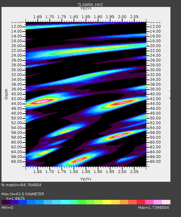
| Estimated Moho Depth: |
43.0 km |
| Estimated Crust Vp/Vs: |
1.66 |
| Assumed Crust Vp: |
6.306 km/s |
| Estimated Crust Vs: |
3.793 km/s |
| Estimated Crust Poisson's Ratio: |
0.22 |
|
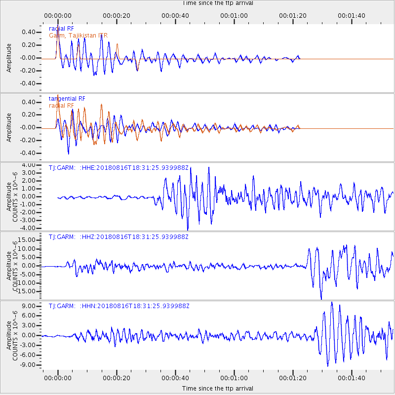
| Radial Match: |
94.784904 % |
| Radial Bump: |
380 |
| Transverse Match: |
92.7954 % |
| Transverse Bump: |
400 |
| SOD ConfigId: |
13570011 |
| Insert Time: |
2019-04-30 19:48:50.016 +0000 |
| GWidth: |
2.5 |
| Max Bumps: |
400 |
| Tol: |
0.001 |
|
Signal To Noise
| Channel | StoN | STA | LTA |
| TJ:GARM: :HHZ:20180816T18:31:25.939988Z | 7.4100194 | 8.545149E-7 | 1.1531885E-7 |
| TJ:GARM: :HHN:20180816T18:31:25.939988Z | 1.5420103 | 1.5321741E-7 | 9.9362126E-8 |
| TJ:GARM: :HHE:20180816T18:31:25.939988Z | 2.6295226 | 3.365957E-7 | 1.2800639E-7 |
| Arrivals |
| Ps | 4.7 SECOND |
| PpPs | 17 SECOND |
| PsPs/PpSs | 22 SECOND |


