You are here: Home > Network List > CI - Caltech Regional Seismic Network Stations List
> Station PHL Parkhill, California, USA > Earthquake Result Viewer
PHL Parkhill, California, USA - Earthquake Result Viewer

| Earthquake location: |
Santa Cruz Islands |
| Earthquake latitude/longitude: |
-10.9/165.4 |
| Earthquake time(UTC): |
1999/12/29 (363) 13:29:19 GMT |
| Earthquake Depth: |
33 km |
| Earthquake Magnitude: |
5.6 MB, 6.8 MS, 6.8 MW, 6.3 MW |
| Earthquake Catalog/Contributor: |
WHDF/NEIC |
|
| Network: |
CI Caltech Regional Seismic Network |
| Station: |
PHL Parkhill, California, USA |
| Lat/Lon: |
35.41 N/120.55 W |
| Elevation: |
351 m |
|
| Distance: |
83.6 deg |
| Az: |
52.24 deg |
| Baz: |
251.936 deg |
| Ray Param: |
0.04604447 |
| Estimated Moho Depth: |
29.75 km |
| Estimated Crust Vp/Vs: |
1.75 |
| Assumed Crust Vp: |
6.183 km/s |
| Estimated Crust Vs: |
3.533 km/s |
| Estimated Crust Poisson's Ratio: |
0.26 |
|
| Radial Match: |
91.894875 % |
| Radial Bump: |
400 |
| Transverse Match: |
80.40325 % |
| Transverse Bump: |
400 |
| SOD ConfigId: |
3787 |
| Insert Time: |
2010-02-26 02:12:13.446 +0000 |
| GWidth: |
2.5 |
| Max Bumps: |
400 |
| Tol: |
0.001 |
|
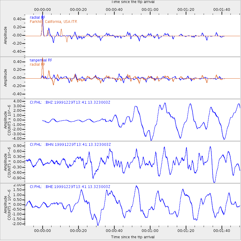
Signal To Noise
| Channel | StoN | STA | LTA |
| CI:PHL: :BHN:19991229T13:41:13.323003Z | 0.62749875 | 7.6174246E-8 | 1.2139346E-7 |
| CI:PHL: :BHE:19991229T13:41:13.323003Z | 0.6765404 | 1.5042073E-7 | 2.2233816E-7 |
| CI:PHL: :BHZ:19991229T13:41:13.323003Z | 1.4124228 | 2.420478E-7 | 1.7137064E-7 |
| Arrivals |
| Ps | 3.7 SECOND |
| PpPs | 13 SECOND |
| PsPs/PpSs | 17 SECOND |


