You are here: Home > Network List > CI - Caltech Regional Seismic Network Stations List
> Station PHL Parkhill, California, USA > Earthquake Result Viewer
PHL Parkhill, California, USA - Earthquake Result Viewer
| Earthquake location: |
New Britain Region, P.N.G. |
| Earthquake latitude/longitude: |
-5.2/150.9 |
| Earthquake time(UTC): |
1999/05/10 (130) 20:33:02 GMT |
| Earthquake Depth: |
138 km |
| Earthquake Magnitude: |
6.5 MB, 6.8 MS, 7.1 MW, 6.5 MB |
| Earthquake Catalog/Contributor: |
WHDF/NEIC |
|
| Network: |
CI Caltech Regional Seismic Network |
| Station: |
PHL Parkhill, California, USA |
| Lat/Lon: |
35.41 N/120.55 W |
| Elevation: |
351 m |
|
| Distance: |
91.8 deg |
| Az: |
54.788 deg |
| Baz: |
264.992 deg |
| Ray Param: |
0.04149558 |
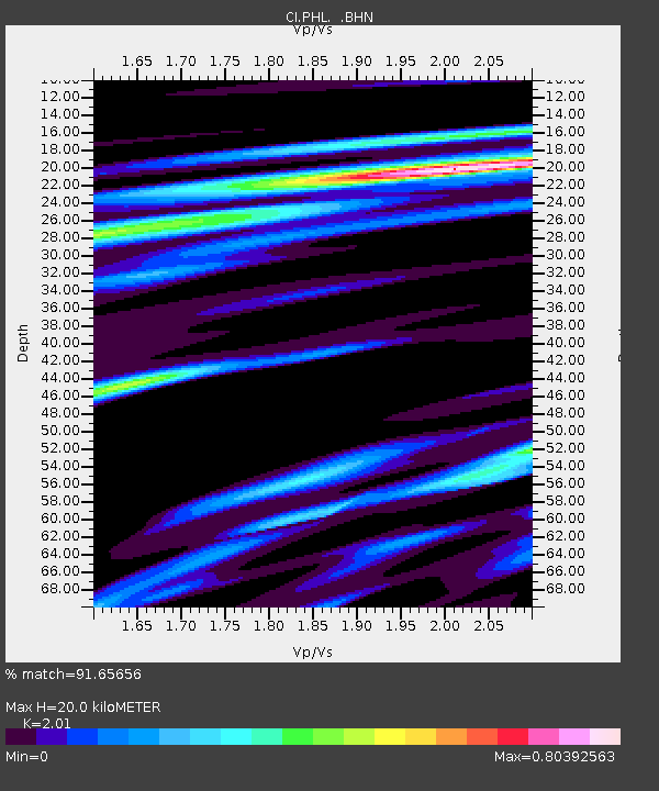
| Estimated Moho Depth: |
20.0 km |
| Estimated Crust Vp/Vs: |
2.01 |
| Assumed Crust Vp: |
6.183 km/s |
| Estimated Crust Vs: |
3.076 km/s |
| Estimated Crust Poisson's Ratio: |
0.34 |
|
| Radial Match: |
91.65656 % |
| Radial Bump: |
400 |
| Transverse Match: |
77.50273 % |
| Transverse Bump: |
400 |
| SOD ConfigId: |
3770 |
| Insert Time: |
2010-02-26 02:12:17.771 +0000 |
| GWidth: |
2.5 |
| Max Bumps: |
400 |
| Tol: |
0.001 |
|
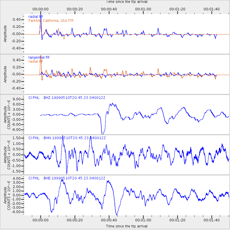
Signal To Noise
| Channel | StoN | STA | LTA |
| CI:PHL: :BHN:19990510T20:45:23.040012Z | 1.3628278 | 2.3015458E-7 | 1.6888016E-7 |
| CI:PHL: :BHE:19990510T20:45:23.040012Z | 1.1496065 | 4.5832658E-7 | 3.9868127E-7 |
| CI:PHL: :BHZ:19990510T20:45:23.040012Z | 1.2584873 | 4.8158165E-7 | 3.8266705E-7 |
| Arrivals |
| Ps | 3.3 SECOND |
| PpPs | 9.6 SECOND |
| PsPs/PpSs | 13 SECOND |


