You are here: Home > Network List > CI - Caltech Regional Seismic Network Stations List
> Station PHL Parkhill, California, USA > Earthquake Result Viewer
PHL Parkhill, California, USA - Earthquake Result Viewer

| Earthquake location: |
Southeast Of Honshu, Japan |
| Earthquake latitude/longitude: |
31.0/142.0 |
| Earthquake time(UTC): |
2002/08/20 (232) 10:59:32 GMT |
| Earthquake Depth: |
9.0 km |
| Earthquake Magnitude: |
5.4 MB, 6.2 MS, 6.3 MW, 6.1 MW |
| Earthquake Catalog/Contributor: |
WHDF/NEIC |
|
| Network: |
CI Caltech Regional Seismic Network |
| Station: |
PHL Parkhill, California, USA |
| Lat/Lon: |
35.41 N/120.55 W |
| Elevation: |
351 m |
|
| Distance: |
78.2 deg |
| Az: |
55.824 deg |
| Baz: |
299.566 deg |
| Ray Param: |
0.049788274 |
| Estimated Moho Depth: |
17.75 km |
| Estimated Crust Vp/Vs: |
1.80 |
| Assumed Crust Vp: |
6.183 km/s |
| Estimated Crust Vs: |
3.44 km/s |
| Estimated Crust Poisson's Ratio: |
0.28 |
|
| Radial Match: |
83.17685 % |
| Radial Bump: |
400 |
| Transverse Match: |
49.517498 % |
| Transverse Bump: |
400 |
| SOD ConfigId: |
3770 |
| Insert Time: |
2010-02-26 02:12:20.113 +0000 |
| GWidth: |
2.5 |
| Max Bumps: |
400 |
| Tol: |
0.001 |
|
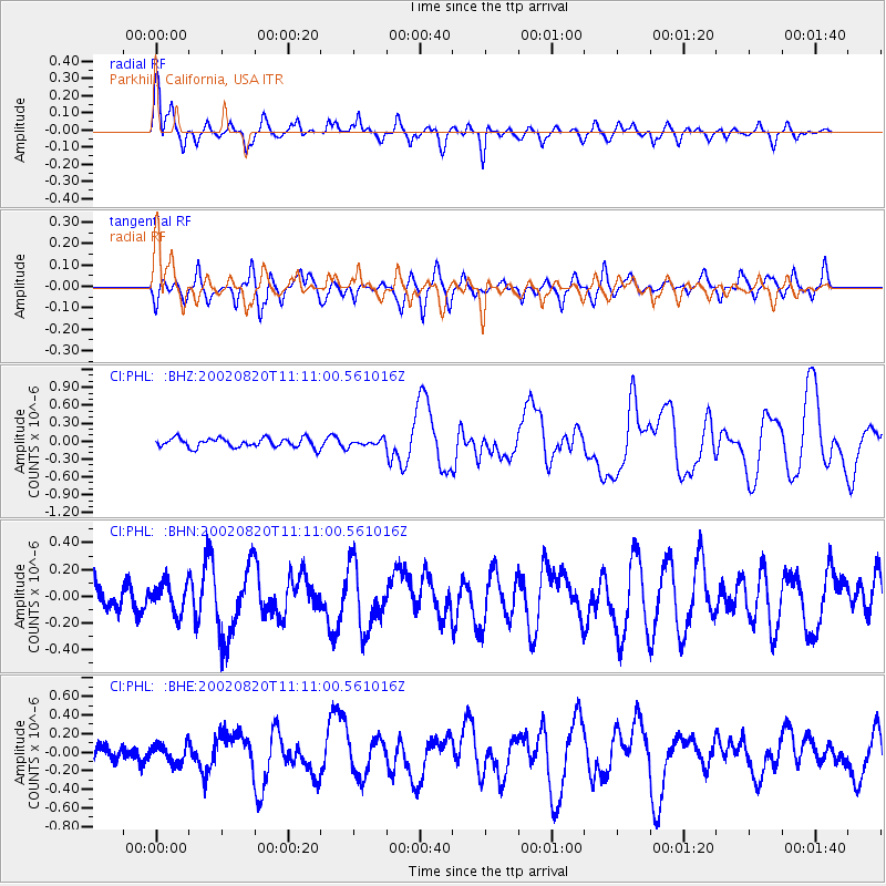
Signal To Noise
| Channel | StoN | STA | LTA |
| CI:PHL: :BHN:20020820T11:11:00.561016Z | 0.9609617 | 1.1365295E-7 | 1.18270016E-7 |
| CI:PHL: :BHE:20020820T11:11:00.561016Z | 0.9304545 | 1.0145327E-7 | 1.0903624E-7 |
| CI:PHL: :BHZ:20020820T11:11:00.561016Z | 0.700415 | 5.381339E-8 | 7.683072E-8 |
| Arrivals |
| Ps | 2.4 SECOND |
| PpPs | 7.8 SECOND |
| PsPs/PpSs | 10 SECOND |


