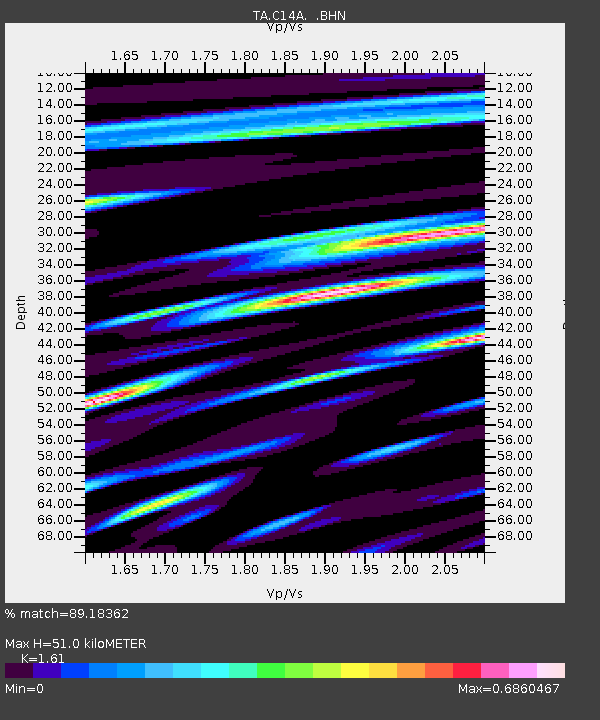
C14A Swan Lake, MT, USA - Earthquake Result Viewer
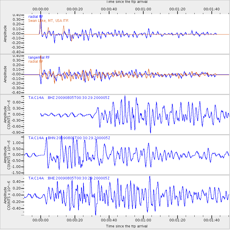
Earthquake location: Southwestern Ryukyu Isl., Japan
Earthquake latitude/longitude: 24.2/125.1
Earthquake time(UTC): 2009/08/05 (217) 00:17:58 GMT
Earthquake Depth: 25 km
Earthquake Magnitude: 5.9 MB, 5.9 MS, 6.2 MW, 6.1 MW
Earthquake Catalog/Contributor: WHDF/NEIC
Network: TA USArray Transportable Network (new EarthScope stations)
Station: C14A Swan Lake, MT, USA
Lat/Lon: 47.77 N/113.75 W
Elevation: 1173 m
Distance: 91.0 deg
Az: 35.266 deg
Baz: 308.617 deg
Ray Param: 0.041631225
Estimated Moho Depth: 51.0 km
Estimated Crust Vp/Vs: 1.61
Assumed Crust Vp: 6.353 km/s
Estimated Crust Vs: 3.946 km/s
Estimated Crust Poisson's Ratio: 0.19
Radial Match: 89.18362 %
Radial Bump: 400
Transverse Match: 84.16902 %
Transverse Bump: 400
SOD ConfigId: 2622
Insert Time: 2010-03-06 14:00:12.086 +0000
GWidth: 2.5
Max Bumps: 400
Tol: 0.001

Signal To Noise

ChannelStoNSTALTA
TA:C14A: :BHN:20090805T00:30:29.200005Z7.70345166.31589E-78.198779E-8
TA:C14A: :BHE:20090805T00:30:29.200005Z2.81507851.2083893E-74.2925603E-8
TA:C14A: :BHZ:20090805T00:30:29.200005Z4.50463152.3523717E-75.2221175E-8
Arrivals
Ps5.0 SECOND
PpPs20 SECOND
PsPs/PpSs25 SECOND