You are here: Home > Network List > TA - USArray Transportable Network (new EarthScope stations) Stations List
> Station C14A Swan Lake, MT, USA > Earthquake Result Viewer
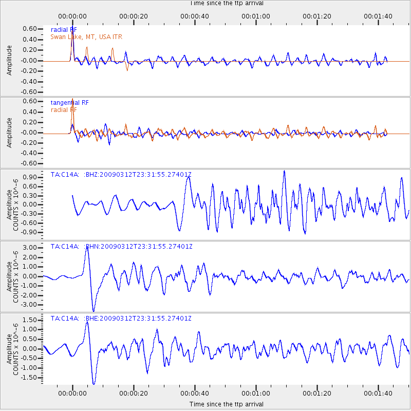
C14A Swan Lake, MT, USA - Earthquake Result Viewer

| Earthquake location: |
South Of Panama |
| Earthquake latitude/longitude: |
5.7/-82.8 |
| Earthquake time(UTC): |
2009/03/12 (071) 23:23:34 GMT |
| Earthquake Depth: |
9.0 km |
| Earthquake Magnitude: |
6.1 MB, 5.9 MS, 6.3 MW, 6.2 MW |
| Earthquake Catalog/Contributor: |
WHDF/NEIC |
|
| Network: |
TA USArray Transportable Network (new EarthScope stations) |
| Station: |
C14A Swan Lake, MT, USA |
| Lat/Lon: |
47.77 N/113.75 W |
| Elevation: |
1173 m |
|
| Distance: |
49.6 deg |
| Az: |
332.87 deg |
| Baz: |
137.724 deg |
| Ray Param: |
0.068604164 |
| Estimated Moho Depth: |
45.75 km |
| Estimated Crust Vp/Vs: |
1.60 |
| Assumed Crust Vp: |
6.353 km/s |
| Estimated Crust Vs: |
3.971 km/s |
| Estimated Crust Poisson's Ratio: |
0.18 |
|
| Radial Match: |
82.75141 % |
| Radial Bump: |
400 |
| Transverse Match: |
75.11812 % |
| Transverse Bump: |
400 |
| SOD ConfigId: |
2658 |
| Insert Time: |
2010-03-06 14:00:30.577 +0000 |
| GWidth: |
2.5 |
| Max Bumps: |
400 |
| Tol: |
0.001 |
|
Signal To Noise
| Channel | StoN | STA | LTA |
| TA:C14A: :BHN:20090312T23:31:55.27401Z | 7.5124393 | 1.1566809E-6 | 1.5396876E-7 |
| TA:C14A: :BHE:20090312T23:31:55.27401Z | 4.6755433 | 5.758909E-7 | 1.2317092E-7 |
| TA:C14A: :BHZ:20090312T23:31:55.27401Z | 1.8104221 | 2.7859048E-7 | 1.538815E-7 |
| Arrivals |
| Ps | 4.6 SECOND |
| PpPs | 18 SECOND |
| PsPs/PpSs | 22 SECOND |


