You are here: Home > Network List > TA - USArray Transportable Network (new EarthScope stations) Stations List
> Station C14A Swan Lake, MT, USA > Earthquake Result Viewer
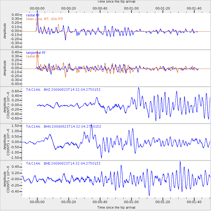
C14A Swan Lake, MT, USA - Earthquake Result Viewer
| Earthquake location: |
New Ireland Region, P.N.G. |
| Earthquake latitude/longitude: |
-5.2/153.7 |
| Earthquake time(UTC): |
2009/06/23 (174) 14:19:17 GMT |
| Earthquake Depth: |
65 km |
| Earthquake Magnitude: |
5.5 MB |
| Earthquake Catalog/Contributor: |
WHDF/NEIC |
|
| Network: |
TA USArray Transportable Network (new EarthScope stations) |
| Station: |
C14A Swan Lake, MT, USA |
| Lat/Lon: |
47.77 N/113.75 W |
| Elevation: |
1173 m |
|
| Distance: |
95.5 deg |
| Az: |
42.616 deg |
| Baz: |
268.392 deg |
| Ray Param: |
0.04071586 |
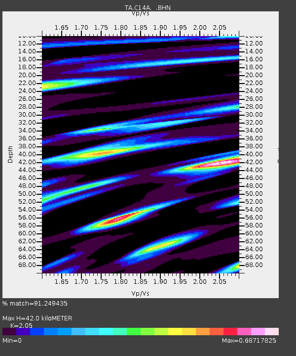
| Estimated Moho Depth: |
42.0 km |
| Estimated Crust Vp/Vs: |
2.05 |
| Assumed Crust Vp: |
6.353 km/s |
| Estimated Crust Vs: |
3.099 km/s |
| Estimated Crust Poisson's Ratio: |
0.34 |
|
| Radial Match: |
91.249435 % |
| Radial Bump: |
400 |
| Transverse Match: |
84.57851 % |
| Transverse Bump: |
400 |
| SOD ConfigId: |
2648 |
| Insert Time: |
2010-03-06 14:00:32.287 +0000 |
| GWidth: |
2.5 |
| Max Bumps: |
400 |
| Tol: |
0.001 |
|
Signal To Noise
| Channel | StoN | STA | LTA |
| TA:C14A: :BHN:20090623T14:32:04.275015Z | 2.9988983 | 1.2883973E-7 | 4.2962355E-8 |
| TA:C14A: :BHE:20090623T14:32:04.275015Z | 1.0624268 | 4.0512884E-8 | 3.81324E-8 |
| TA:C14A: :BHZ:20090623T14:32:04.275015Z | 1.6486663 | 7.3529854E-8 | 4.45996E-8 |
| Arrivals |
| Ps | 7.1 SECOND |
| PpPs | 20 SECOND |
| PsPs/PpSs | 27 SECOND |


