You are here: Home > Network List > TA - USArray Transportable Network (new EarthScope stations) Stations List
> Station C14A Swan Lake, MT, USA > Earthquake Result Viewer
C14A Swan Lake, MT, USA - Earthquake Result Viewer
| Earthquake location: |
Kuril Islands |
| Earthquake latitude/longitude: |
46.9/153.7 |
| Earthquake time(UTC): |
2006/11/15 (319) 11:33:23 GMT |
| Earthquake Depth: |
10 km |
| Earthquake Magnitude: |
5.5 MB |
| Earthquake Catalog/Contributor: |
WHDF/NEIC |
|
| Network: |
TA USArray Transportable Network (new EarthScope stations) |
| Station: |
C14A Swan Lake, MT, USA |
| Lat/Lon: |
47.77 N/113.75 W |
| Elevation: |
1173 m |
|
| Distance: |
58.9 deg |
| Az: |
51.916 deg |
| Baz: |
306.808 deg |
| Ray Param: |
0.062545955 |
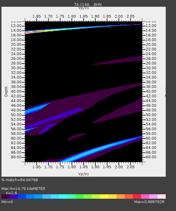
| Estimated Moho Depth: |
14.75 km |
| Estimated Crust Vp/Vs: |
1.60 |
| Assumed Crust Vp: |
6.353 km/s |
| Estimated Crust Vs: |
3.971 km/s |
| Estimated Crust Poisson's Ratio: |
0.18 |
|
| Radial Match: |
94.84766 % |
| Radial Bump: |
400 |
| Transverse Match: |
77.88442 % |
| Transverse Bump: |
214 |
| SOD ConfigId: |
2564 |
| Insert Time: |
2010-03-06 14:00:43.499 +0000 |
| GWidth: |
2.5 |
| Max Bumps: |
400 |
| Tol: |
0.001 |
|

Signal To Noise
| Channel | StoN | STA | LTA |
| TA:C14A: :BHN:20061115T11:42:51.724011Z | 0.5277507 | 1.794563E-5 | 3.400399E-5 |
| TA:C14A: :BHE:20061115T11:42:51.724011Z | 4.1674423 | 1.3074173E-4 | 3.1372172E-5 |
| TA:C14A: :BHZ:20061115T11:42:51.724011Z | 0.9555119 | 3.7476246E-5 | 3.922112E-5 |
| Arrivals |
| Ps | 1.5 SECOND |
| PpPs | 5.7 SECOND |
| PsPs/PpSs | 7.2 SECOND |


