You are here: Home > Network List > IU - Global Seismograph Network (GSN - IRIS/USGS) Stations List
> Station KBL Kabul, Afghanistan > Earthquake Result Viewer
KBL Kabul, Afghanistan - Earthquake Result Viewer
| Earthquake location: |
Volcano Islands, Japan Region |
| Earthquake latitude/longitude: |
23.4/143.3 |
| Earthquake time(UTC): |
2018/08/16 (228) 18:22:53 GMT |
| Earthquake Depth: |
20 km |
| Earthquake Magnitude: |
6.3 Mww |
| Earthquake Catalog/Contributor: |
NEIC PDE/us |
|
| Network: |
IU Global Seismograph Network (GSN - IRIS/USGS) |
| Station: |
KBL Kabul, Afghanistan |
| Lat/Lon: |
34.54 N/69.04 E |
| Elevation: |
1920 m |
|
| Distance: |
64.6 deg |
| Az: |
298.415 deg |
| Baz: |
78.123 deg |
| Ray Param: |
0.058789566 |
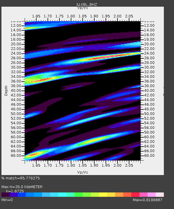
| Estimated Moho Depth: |
35.0 km |
| Estimated Crust Vp/Vs: |
1.67 |
| Assumed Crust Vp: |
6.641 km/s |
| Estimated Crust Vs: |
3.971 km/s |
| Estimated Crust Poisson's Ratio: |
0.22 |
|
| Radial Match: |
95.778275 % |
| Radial Bump: |
400 |
| Transverse Match: |
86.86125 % |
| Transverse Bump: |
400 |
| SOD ConfigId: |
13570011 |
| Insert Time: |
2019-04-30 20:06:07.169 +0000 |
| GWidth: |
2.5 |
| Max Bumps: |
400 |
| Tol: |
0.001 |
|
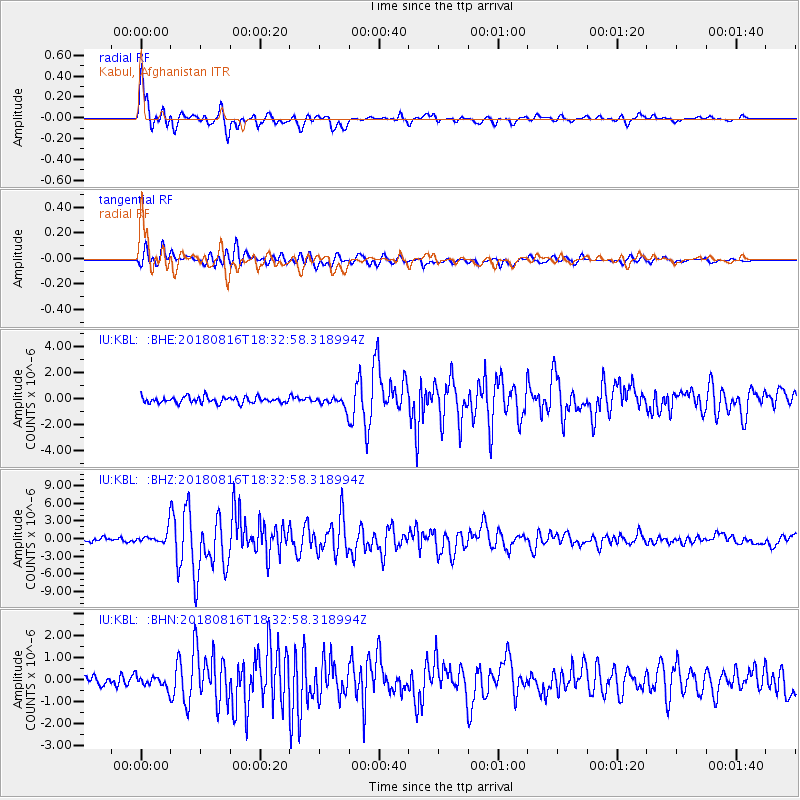
Signal To Noise
| Channel | StoN | STA | LTA |
| IU:KBL: :BHZ:20180816T18:32:58.318994Z | 3.2536173 | 1.2565653E-6 | 3.862056E-7 |
| IU:KBL: :BHN:20180816T18:32:58.318994Z | 1.1021751 | 2.6777843E-7 | 2.429545E-7 |
| IU:KBL: :BHE:20180816T18:32:58.318994Z | 1.6302042 | 3.8752293E-7 | 2.3771435E-7 |
| Arrivals |
| Ps | 3.7 SECOND |
| PpPs | 13 SECOND |
| PsPs/PpSs | 17 SECOND |


