You are here: Home > Network List > US - United States National Seismic Network Stations List
> Station MSO Missoula, Montana, USA > Earthquake Result Viewer
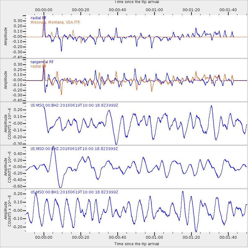
MSO Missoula, Montana, USA - Earthquake Result Viewer
*The percent match for this event was below the threshold and hence no stack was calculated.
| Earthquake location: |
Vanuatu Islands |
| Earthquake latitude/longitude: |
-20.3/169.1 |
| Earthquake time(UTC): |
2016/06/19 (171) 09:47:23 GMT |
| Earthquake Depth: |
13 km |
| Earthquake Magnitude: |
6.3 MWW, 6.2 MWB, 6.3 MWC, 6.6 MI |
| Earthquake Catalog/Contributor: |
NEIC PDE/NEIC COMCAT |
|
| Network: |
US United States National Seismic Network |
| Station: |
MSO Missoula, Montana, USA |
| Lat/Lon: |
46.83 N/113.94 W |
| Elevation: |
1264 m |
|
| Distance: |
96.0 deg |
| Az: |
42.277 deg |
| Baz: |
246.891 deg |
| Ray Param: |
$rayparam |
*The percent match for this event was below the threshold and hence was not used in the summary stack. |
|
| Radial Match: |
74.73871 % |
| Radial Bump: |
400 |
| Transverse Match: |
70.9991 % |
| Transverse Bump: |
400 |
| SOD ConfigId: |
1634031 |
| Insert Time: |
2016-07-03 09:49:49.228 +0000 |
| GWidth: |
2.5 |
| Max Bumps: |
400 |
| Tol: |
0.001 |
|
Signal To Noise
| Channel | StoN | STA | LTA |
| US:MSO:00:BHZ:20160619T10:00:18.823999Z | 1.854499 | 2.1985706E-7 | 1.18553345E-7 |
| US:MSO:00:BH1:20160619T10:00:18.823999Z | 1.4557099 | 1.0422035E-7 | 7.159417E-8 |
| US:MSO:00:BH2:20160619T10:00:18.823999Z | 0.80710655 | 6.045567E-8 | 7.490419E-8 |
| Arrivals |
| Ps | |
| PpPs | |
| PsPs/PpSs | |


