You are here: Home > Network List > UW - Pacific Northwest Regional Seismic Network Stations List
> Station PHIN Phinny Hill Vineyards, Prosser, WA, USA > Earthquake Result Viewer
PHIN Phinny Hill Vineyards, Prosser, WA, USA - Earthquake Result Viewer
| Earthquake location: |
Volcano Islands, Japan Region |
| Earthquake latitude/longitude: |
23.4/143.3 |
| Earthquake time(UTC): |
2018/08/16 (228) 18:22:53 GMT |
| Earthquake Depth: |
20 km |
| Earthquake Magnitude: |
6.3 Mww |
| Earthquake Catalog/Contributor: |
NEIC PDE/us |
|
| Network: |
UW Pacific Northwest Regional Seismic Network |
| Station: |
PHIN Phinny Hill Vineyards, Prosser, WA, USA |
| Lat/Lon: |
45.90 N/119.93 W |
| Elevation: |
227 m |
|
| Distance: |
78.0 deg |
| Az: |
45.151 deg |
| Baz: |
291.187 deg |
| Ray Param: |
0.049907558 |
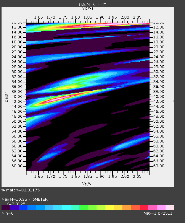
| Estimated Moho Depth: |
10.25 km |
| Estimated Crust Vp/Vs: |
2.01 |
| Assumed Crust Vp: |
6.571 km/s |
| Estimated Crust Vs: |
3.265 km/s |
| Estimated Crust Poisson's Ratio: |
0.34 |
|
| Radial Match: |
86.81175 % |
| Radial Bump: |
400 |
| Transverse Match: |
64.24666 % |
| Transverse Bump: |
400 |
| SOD ConfigId: |
13570011 |
| Insert Time: |
2019-04-30 20:09:02.662 +0000 |
| GWidth: |
2.5 |
| Max Bumps: |
400 |
| Tol: |
0.001 |
|

Signal To Noise
| Channel | StoN | STA | LTA |
| UW:PHIN: :HHZ:20180816T18:34:19.078027Z | 0.7596432 | 2.8912834E-7 | 3.806107E-7 |
| UW:PHIN: :HHN:20180816T18:34:19.078027Z | 1.2699807 | 1.6140187E-7 | 1.2709002E-7 |
| UW:PHIN: :HHE:20180816T18:34:19.078027Z | 1.0684661 | 1.9888962E-7 | 1.8614502E-7 |
| Arrivals |
| Ps | 1.6 SECOND |
| PpPs | 4.6 SECOND |
| PsPs/PpSs | 6.2 SECOND |


