You are here: Home > Network List > 2H - Interim Broadband Monitoring of the Mount Erebus Volcano Stations List
> Station CONZ Mt Erebus site CONZ > Earthquake Result Viewer
CONZ Mt Erebus site CONZ - Earthquake Result Viewer
| Earthquake location: |
Flores Sea |
| Earthquake latitude/longitude: |
-7.4/119.8 |
| Earthquake time(UTC): |
2018/08/17 (229) 15:35:02 GMT |
| Earthquake Depth: |
539 km |
| Earthquake Magnitude: |
6.5 Mww |
| Earthquake Catalog/Contributor: |
NEIC PDE/us |
|
| Network: |
2H Interim Broadband Monitoring of the Mount Erebus Volcano |
| Station: |
CONZ Mt Erebus site CONZ |
| Lat/Lon: |
77.53 S/167.08 E |
| Elevation: |
3433 m |
|
| Distance: |
74.3 deg |
| Az: |
170.456 deg |
| Baz: |
310.816 deg |
| Ray Param: |
0.0507303 |
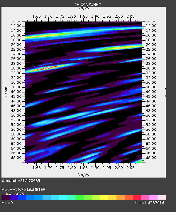
| Estimated Moho Depth: |
29.75 km |
| Estimated Crust Vp/Vs: |
1.69 |
| Assumed Crust Vp: |
6.183 km/s |
| Estimated Crust Vs: |
3.664 km/s |
| Estimated Crust Poisson's Ratio: |
0.23 |
|
| Radial Match: |
81.170685 % |
| Radial Bump: |
400 |
| Transverse Match: |
78.59347 % |
| Transverse Bump: |
400 |
| SOD ConfigId: |
13570011 |
| Insert Time: |
2019-04-30 20:10:02.398 +0000 |
| GWidth: |
2.5 |
| Max Bumps: |
400 |
| Tol: |
0.001 |
|

Signal To Noise
| Channel | StoN | STA | LTA |
| 2H:CONZ: :HHZ:20180817T15:45:13.70501Z | 22.026783 | 3.4197826E-6 | 1.5525565E-7 |
| 2H:CONZ: :HH1:20180817T15:45:13.70501Z | 10.034001 | 1.181913E-6 | 1.177908E-7 |
| 2H:CONZ: :HH2:20180817T15:45:13.70501Z | 15.729137 | 2.210896E-6 | 1.4056053E-7 |
| Arrivals |
| Ps | 3.4 SECOND |
| PpPs | 13 SECOND |
| PsPs/PpSs | 16 SECOND |


