You are here: Home > Network List > AV - Alaska Volcano Observatory Stations List
> Station PLBL Mt. Peulik Volcano, Alaska > Earthquake Result Viewer
PLBL Mt. Peulik Volcano, Alaska - Earthquake Result Viewer
*The percent match for this event was below the threshold and hence no stack was calculated.
| Earthquake location: |
Flores Sea |
| Earthquake latitude/longitude: |
-7.4/119.8 |
| Earthquake time(UTC): |
2018/08/17 (229) 15:35:02 GMT |
| Earthquake Depth: |
539 km |
| Earthquake Magnitude: |
6.5 Mww |
| Earthquake Catalog/Contributor: |
NEIC PDE/us |
|
| Network: |
AV Alaska Volcano Observatory |
| Station: |
PLBL Mt. Peulik Volcano, Alaska |
| Lat/Lon: |
57.70 N/156.82 W |
| Elevation: |
461 m |
|
| Distance: |
92.7 deg |
| Az: |
32.27 deg |
| Baz: |
260.459 deg |
| Ray Param: |
$rayparam |
*The percent match for this event was below the threshold and hence was not used in the summary stack. |
|
| Radial Match: |
71.18526 % |
| Radial Bump: |
400 |
| Transverse Match: |
50.966 % |
| Transverse Bump: |
400 |
| SOD ConfigId: |
13570011 |
| Insert Time: |
2019-04-30 20:11:03.525 +0000 |
| GWidth: |
2.5 |
| Max Bumps: |
400 |
| Tol: |
0.001 |
|
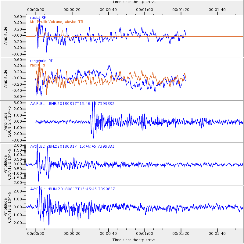
Signal To Noise
| Channel | StoN | STA | LTA |
| AV:PLBL: :BHZ:20180817T15:46:45.739983Z | 10.653943 | 7.539133E-7 | 7.076378E-8 |
| AV:PLBL: :BHN:20180817T15:46:45.739983Z | 5.6686363 | 9.2576727E-7 | 1.6331393E-7 |
| AV:PLBL: :BHE:20180817T15:46:45.739983Z | 11.485106 | 1.3331565E-6 | 1.1607698E-7 |
| Arrivals |
| Ps | |
| PpPs | |
| PsPs/PpSs | |


