You are here: Home > Network List > TA - USArray Transportable Network (new EarthScope stations) Stations List
> Station C14A Swan Lake, MT, USA > Earthquake Result Viewer
C14A Swan Lake, MT, USA - Earthquake Result Viewer
| Earthquake location: |
East Of Kuril Islands |
| Earthquake latitude/longitude: |
46.2/154.5 |
| Earthquake time(UTC): |
2007/01/13 (013) 04:23:21 GMT |
| Earthquake Depth: |
10 km |
| Earthquake Magnitude: |
7.3 MB, 8.2 MS, 8.1 MW, 7.9 MW |
| Earthquake Catalog/Contributor: |
WHDF/NEIC |
|
| Network: |
TA USArray Transportable Network (new EarthScope stations) |
| Station: |
C14A Swan Lake, MT, USA |
| Lat/Lon: |
47.77 N/113.75 W |
| Elevation: |
1173 m |
|
| Distance: |
58.8 deg |
| Az: |
51.992 deg |
| Baz: |
305.845 deg |
| Ray Param: |
0.06257814 |
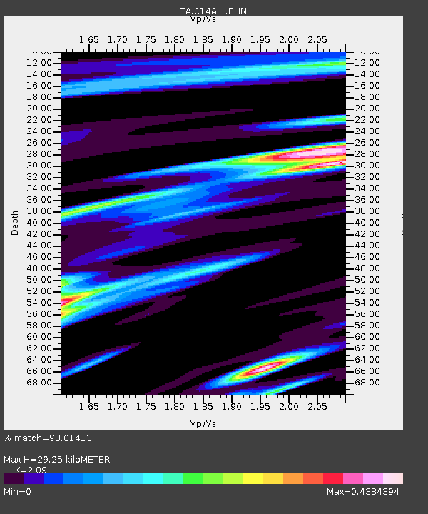
| Estimated Moho Depth: |
29.25 km |
| Estimated Crust Vp/Vs: |
2.09 |
| Assumed Crust Vp: |
6.353 km/s |
| Estimated Crust Vs: |
3.04 km/s |
| Estimated Crust Poisson's Ratio: |
0.35 |
|
| Radial Match: |
98.01413 % |
| Radial Bump: |
329 |
| Transverse Match: |
85.37493 % |
| Transverse Bump: |
400 |
| SOD ConfigId: |
2564 |
| Insert Time: |
2010-03-06 14:01:53.052 +0000 |
| GWidth: |
2.5 |
| Max Bumps: |
400 |
| Tol: |
0.001 |
|

Signal To Noise
| Channel | StoN | STA | LTA |
| TA:C14A: :BHN:20070113T04:32:48.750027Z | 6.3166485 | 8.3626526E-7 | 1.3239065E-7 |
| TA:C14A: :BHE:20070113T04:32:48.750027Z | 9.471167 | 1.1420251E-6 | 1.2057914E-7 |
| TA:C14A: :BHZ:20070113T04:32:48.750027Z | 9.857526 | 2.7079077E-6 | 2.747046E-7 |
| Arrivals |
| Ps | 5.2 SECOND |
| PpPs | 14 SECOND |
| PsPs/PpSs | 19 SECOND |


