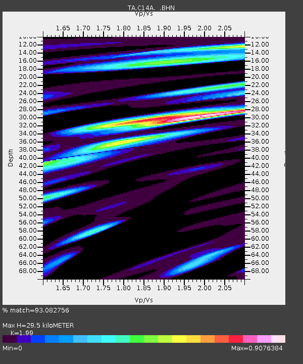
C14A Swan Lake, MT, USA - Earthquake Result Viewer
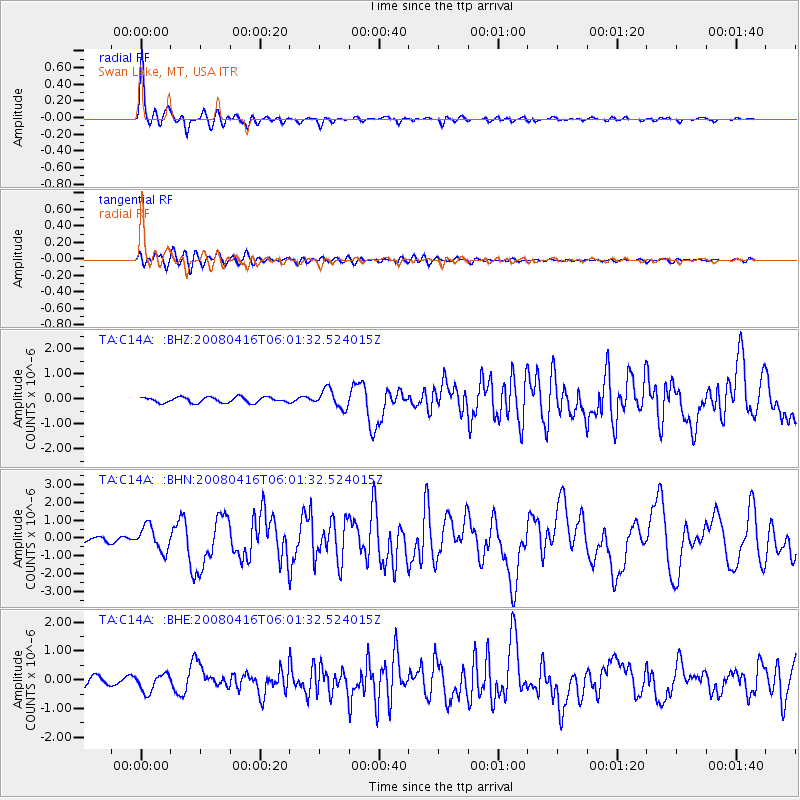
Earthquake location: Andreanof Islands, Aleutian Is.
Earthquake latitude/longitude: 51.9/-179.2
Earthquake time(UTC): 2008/04/16 (107) 05:54:19 GMT
Earthquake Depth: 13 km
Earthquake Magnitude: 6.1 MB, 6.5 MS, 6.6 MW, 6.6 MW
Earthquake Catalog/Contributor: WHDF/NEIC
Network: TA USArray Transportable Network (new EarthScope stations)
Station: C14A Swan Lake, MT, USA
Lat/Lon: 47.77 N/113.75 W
Elevation: 1173 m
Distance: 41.1 deg
Az: 68.844 deg
Baz: 301.02 deg
Ray Param: 0.07397624
Estimated Moho Depth: 29.5 km
Estimated Crust Vp/Vs: 1.99
Assumed Crust Vp: 6.353 km/s
Estimated Crust Vs: 3.192 km/s
Estimated Crust Poisson's Ratio: 0.33
Radial Match: 93.082756 %
Radial Bump: 354
Transverse Match: 77.95532 %
Transverse Bump: 400
SOD ConfigId: 2504
Insert Time: 2010-03-06 14:02:01.388 +0000
GWidth: 2.5
Max Bumps: 400
Tol: 0.001

Signal To Noise

ChannelStoNSTALTA
TA:C14A: :BHN:20080416T06:01:32.524015Z7.0032376.886313E-79.833043E-8
TA:C14A: :BHE:20080416T06:01:32.524015Z2.58937383.097708E-71.1963154E-7
TA:C14A: :BHZ:20080416T06:01:32.524015Z3.28253723.6459306E-71.1107051E-7
Arrivals
Ps4.9 SECOND
PpPs13 SECOND
PsPs/PpSs18 SECOND