You are here: Home > Network List > S - Seismographs in Schools Projects Stations List
> Station AUBRN Burnie High School, Burnie, TAS > Earthquake Result Viewer
AUBRN Burnie High School, Burnie, TAS - Earthquake Result Viewer
| Earthquake location: |
Flores Sea |
| Earthquake latitude/longitude: |
-7.4/119.8 |
| Earthquake time(UTC): |
2018/08/17 (229) 15:35:02 GMT |
| Earthquake Depth: |
539 km |
| Earthquake Magnitude: |
6.5 Mww |
| Earthquake Catalog/Contributor: |
NEIC PDE/us |
|
| Network: |
S Seismographs in Schools Projects |
| Station: |
AUBRN Burnie High School, Burnie, TAS |
| Lat/Lon: |
41.04 S/145.87 E |
| Elevation: |
10 m |
|
| Distance: |
40.7 deg |
| Az: |
149.395 deg |
| Baz: |
318.125 deg |
| Ray Param: |
0.07154814 |
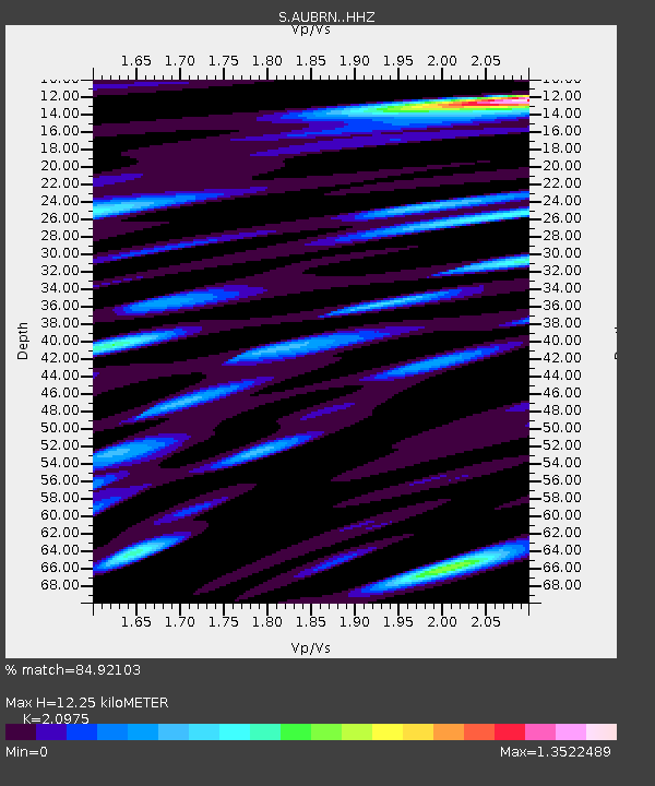
| Estimated Moho Depth: |
12.25 km |
| Estimated Crust Vp/Vs: |
2.10 |
| Assumed Crust Vp: |
6.477 km/s |
| Estimated Crust Vs: |
3.088 km/s |
| Estimated Crust Poisson's Ratio: |
0.35 |
|
| Radial Match: |
84.92103 % |
| Radial Bump: |
400 |
| Transverse Match: |
64.33964 % |
| Transverse Bump: |
400 |
| SOD ConfigId: |
13570011 |
| Insert Time: |
2019-04-30 20:13:14.876 +0000 |
| GWidth: |
2.5 |
| Max Bumps: |
400 |
| Tol: |
0.001 |
|

Signal To Noise
| Channel | StoN | STA | LTA |
| S:AUBRN: :HHZ:20180817T15:41:25.779991Z | 16.264874 | 1.5111822E-5 | 9.2910784E-7 |
| S:AUBRN: :HHN:20180817T15:41:25.779991Z | 6.007486 | 5.90777E-6 | 9.834015E-7 |
| S:AUBRN: :HHE:20180817T15:41:25.779991Z | 8.358814 | 9.000756E-6 | 1.0767982E-6 |
| Arrivals |
| Ps | 2.2 SECOND |
| PpPs | 5.5 SECOND |
| PsPs/PpSs | 7.7 SECOND |


