You are here: Home > Network List > TA - USArray Transportable Network (new EarthScope stations) Stations List
> Station A21K Barrow, AK, USA > Earthquake Result Viewer
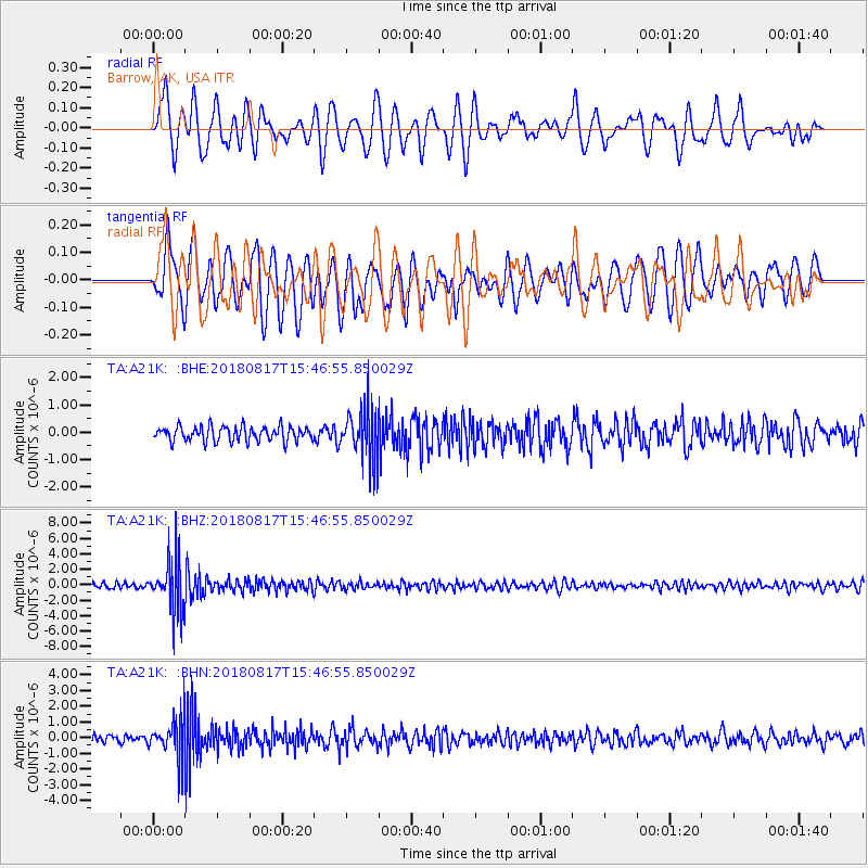
A21K Barrow, AK, USA - Earthquake Result Viewer
*The percent match for this event was below the threshold and hence no stack was calculated.
| Earthquake location: |
Flores Sea |
| Earthquake latitude/longitude: |
-7.4/119.8 |
| Earthquake time(UTC): |
2018/08/17 (229) 15:35:02 GMT |
| Earthquake Depth: |
539 km |
| Earthquake Magnitude: |
6.5 Mww |
| Earthquake Catalog/Contributor: |
NEIC PDE/us |
|
| Network: |
TA USArray Transportable Network (new EarthScope stations) |
| Station: |
A21K Barrow, AK, USA |
| Lat/Lon: |
71.32 N/156.62 W |
| Elevation: |
577 m |
|
| Distance: |
94.9 deg |
| Az: |
18.743 deg |
| Baz: |
261.542 deg |
| Ray Param: |
$rayparam |
*The percent match for this event was below the threshold and hence was not used in the summary stack. |
|
| Radial Match: |
72.52922 % |
| Radial Bump: |
400 |
| Transverse Match: |
52.88047 % |
| Transverse Bump: |
400 |
| SOD ConfigId: |
13570011 |
| Insert Time: |
2019-04-30 20:13:38.195 +0000 |
| GWidth: |
2.5 |
| Max Bumps: |
400 |
| Tol: |
0.001 |
|
Signal To Noise
| Channel | StoN | STA | LTA |
| TA:A21K: :BHZ:20180817T15:46:55.850029Z | 8.9723425 | 3.3966232E-6 | 3.7856594E-7 |
| TA:A21K: :BHN:20180817T15:46:55.850029Z | 3.7810354 | 1.2815701E-6 | 3.3894685E-7 |
| TA:A21K: :BHE:20180817T15:46:55.850029Z | 3.242833 | 8.7763067E-7 | 2.7063703E-7 |
| Arrivals |
| Ps | |
| PpPs | |
| PsPs/PpSs | |


