You are here: Home > Network List > TA - USArray Transportable Network (new EarthScope stations) Stations List
> Station C16K Lisburne Hills, AK, USA > Earthquake Result Viewer
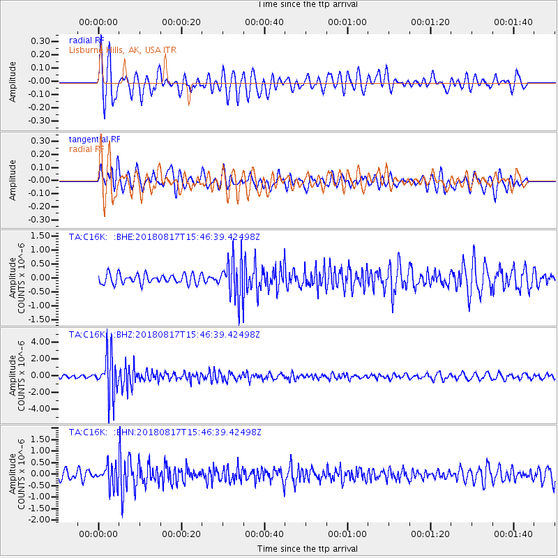
C16K Lisburne Hills, AK, USA - Earthquake Result Viewer
*The percent match for this event was below the threshold and hence no stack was calculated.
| Earthquake location: |
Flores Sea |
| Earthquake latitude/longitude: |
-7.4/119.8 |
| Earthquake time(UTC): |
2018/08/17 (229) 15:35:02 GMT |
| Earthquake Depth: |
539 km |
| Earthquake Magnitude: |
6.5 Mww |
| Earthquake Catalog/Contributor: |
NEIC PDE/us |
|
| Network: |
TA USArray Transportable Network (new EarthScope stations) |
| Station: |
C16K Lisburne Hills, AK, USA |
| Lat/Lon: |
68.27 N/165.34 W |
| Elevation: |
102 m |
|
| Distance: |
91.3 deg |
| Az: |
21.066 deg |
| Baz: |
253.229 deg |
| Ray Param: |
$rayparam |
*The percent match for this event was below the threshold and hence was not used in the summary stack. |
|
| Radial Match: |
70.80626 % |
| Radial Bump: |
400 |
| Transverse Match: |
45.169884 % |
| Transverse Bump: |
400 |
| SOD ConfigId: |
13570011 |
| Insert Time: |
2019-04-30 20:13:43.230 +0000 |
| GWidth: |
2.5 |
| Max Bumps: |
400 |
| Tol: |
0.001 |
|
Signal To Noise
| Channel | StoN | STA | LTA |
| TA:C16K: :BHZ:20180817T15:46:39.42498Z | 9.486971 | 2.4348803E-6 | 2.566552E-7 |
| TA:C16K: :BHN:20180817T15:46:39.42498Z | 2.0326672 | 4.5373216E-7 | 2.232201E-7 |
| TA:C16K: :BHE:20180817T15:46:39.42498Z | 3.7145875 | 6.2722495E-7 | 1.6885454E-7 |
| Arrivals |
| Ps | |
| PpPs | |
| PsPs/PpSs | |


