You are here: Home > Network List > TA - USArray Transportable Network (new EarthScope stations) Stations List
> Station E18K Tukpahlearik Creek, AK, USA > Earthquake Result Viewer
E18K Tukpahlearik Creek, AK, USA - Earthquake Result Viewer
| Earthquake location: |
Flores Sea |
| Earthquake latitude/longitude: |
-7.4/119.8 |
| Earthquake time(UTC): |
2018/08/17 (229) 15:35:02 GMT |
| Earthquake Depth: |
539 km |
| Earthquake Magnitude: |
6.5 Mww |
| Earthquake Catalog/Contributor: |
NEIC PDE/us |
|
| Network: |
TA USArray Transportable Network (new EarthScope stations) |
| Station: |
E18K Tukpahlearik Creek, AK, USA |
| Lat/Lon: |
67.42 N/160.60 W |
| Elevation: |
297 m |
|
| Distance: |
92.8 deg |
| Az: |
22.349 deg |
| Baz: |
257.57 deg |
| Ray Param: |
0.040954266 |
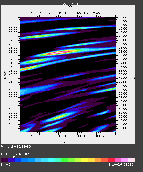
| Estimated Moho Depth: |
28.25 km |
| Estimated Crust Vp/Vs: |
1.80 |
| Assumed Crust Vp: |
6.276 km/s |
| Estimated Crust Vs: |
3.482 km/s |
| Estimated Crust Poisson's Ratio: |
0.28 |
|
| Radial Match: |
82.88985 % |
| Radial Bump: |
400 |
| Transverse Match: |
76.40469 % |
| Transverse Bump: |
400 |
| SOD ConfigId: |
13570011 |
| Insert Time: |
2019-04-30 20:13:48.846 +0000 |
| GWidth: |
2.5 |
| Max Bumps: |
400 |
| Tol: |
0.001 |
|
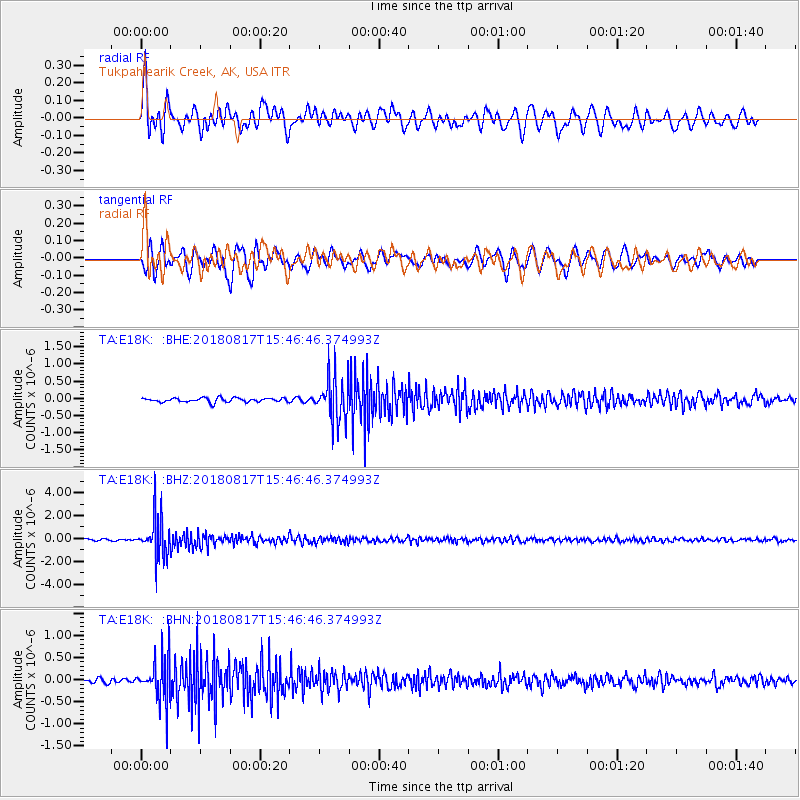
Signal To Noise
| Channel | StoN | STA | LTA |
| TA:E18K: :BHZ:20180817T15:46:46.374993Z | 27.87876 | 1.7213829E-6 | 6.174532E-8 |
| TA:E18K: :BHN:20180817T15:46:46.374993Z | 9.63095 | 4.8460504E-7 | 5.031747E-8 |
| TA:E18K: :BHE:20180817T15:46:46.374993Z | 9.392866 | 5.7027984E-7 | 6.071415E-8 |
| Arrivals |
| Ps | 3.7 SECOND |
| PpPs | 12 SECOND |
| PsPs/PpSs | 16 SECOND |


