You are here: Home > Network List > TA - USArray Transportable Network (new EarthScope stations) Stations List
> Station C14A Swan Lake, MT, USA > Earthquake Result Viewer
C14A Swan Lake, MT, USA - Earthquake Result Viewer
| Earthquake location: |
South Of Panama |
| Earthquake latitude/longitude: |
5.0/-82.7 |
| Earthquake time(UTC): |
2008/06/17 (169) 17:42:09 GMT |
| Earthquake Depth: |
10 km |
| Earthquake Magnitude: |
5.6 MB, 5.3 MS, 5.9 MW, 5.9 MW |
| Earthquake Catalog/Contributor: |
WHDF/NEIC |
|
| Network: |
TA USArray Transportable Network (new EarthScope stations) |
| Station: |
C14A Swan Lake, MT, USA |
| Lat/Lon: |
47.77 N/113.75 W |
| Elevation: |
1173 m |
|
| Distance: |
50.2 deg |
| Az: |
333.052 deg |
| Baz: |
137.991 deg |
| Ray Param: |
0.06818642 |
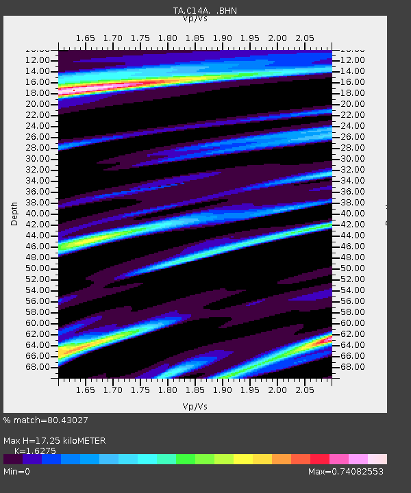
| Estimated Moho Depth: |
17.25 km |
| Estimated Crust Vp/Vs: |
1.63 |
| Assumed Crust Vp: |
6.353 km/s |
| Estimated Crust Vs: |
3.904 km/s |
| Estimated Crust Poisson's Ratio: |
0.20 |
|
| Radial Match: |
80.43027 % |
| Radial Bump: |
400 |
| Transverse Match: |
62.959778 % |
| Transverse Bump: |
400 |
| SOD ConfigId: |
2504 |
| Insert Time: |
2010-03-06 14:02:24.501 +0000 |
| GWidth: |
2.5 |
| Max Bumps: |
400 |
| Tol: |
0.001 |
|
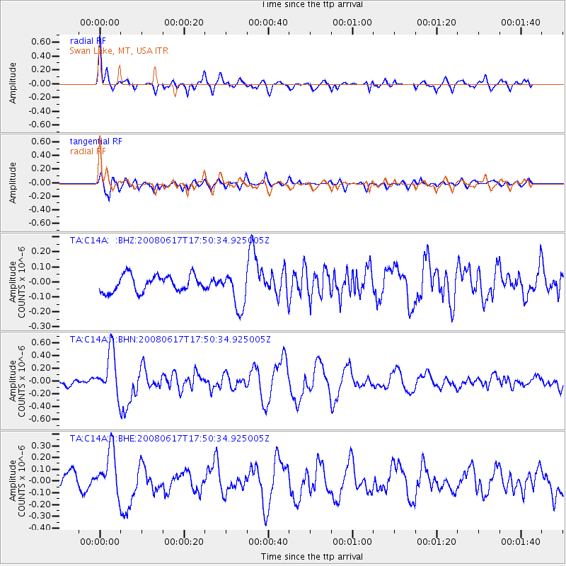
Signal To Noise
| Channel | StoN | STA | LTA |
| TA:C14A: :BHN:20080617T17:50:34.925005Z | 5.1986766 | 3.6087582E-7 | 6.941686E-8 |
| TA:C14A: :BHE:20080617T17:50:34.925005Z | 2.8799424 | 1.9699397E-7 | 6.8402045E-8 |
| TA:C14A: :BHZ:20080617T17:50:34.925005Z | 2.3490105 | 1.281199E-7 | 5.4542074E-8 |
| Arrivals |
| Ps | 1.8 SECOND |
| PpPs | 6.7 SECOND |
| PsPs/PpSs | 8.5 SECOND |


