You are here: Home > Network List > TA - USArray Transportable Network (new EarthScope stations) Stations List
> Station F20K Avaraart Lake, AK, USA > Earthquake Result Viewer
F20K Avaraart Lake, AK, USA - Earthquake Result Viewer
| Earthquake location: |
Flores Sea |
| Earthquake latitude/longitude: |
-7.4/119.8 |
| Earthquake time(UTC): |
2018/08/17 (229) 15:35:02 GMT |
| Earthquake Depth: |
539 km |
| Earthquake Magnitude: |
6.5 Mww |
| Earthquake Catalog/Contributor: |
NEIC PDE/us |
|
| Network: |
TA USArray Transportable Network (new EarthScope stations) |
| Station: |
F20K Avaraart Lake, AK, USA |
| Lat/Lon: |
67.05 N/155.73 W |
| Elevation: |
136 m |
|
| Distance: |
94.6 deg |
| Az: |
23.055 deg |
| Baz: |
262.018 deg |
| Ray Param: |
0.04047749 |
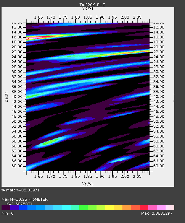
| Estimated Moho Depth: |
16.25 km |
| Estimated Crust Vp/Vs: |
1.61 |
| Assumed Crust Vp: |
6.522 km/s |
| Estimated Crust Vs: |
4.057 km/s |
| Estimated Crust Poisson's Ratio: |
0.18 |
|
| Radial Match: |
85.33971 % |
| Radial Bump: |
400 |
| Transverse Match: |
85.831184 % |
| Transverse Bump: |
400 |
| SOD ConfigId: |
13570011 |
| Insert Time: |
2019-04-30 20:13:57.602 +0000 |
| GWidth: |
2.5 |
| Max Bumps: |
400 |
| Tol: |
0.001 |
|
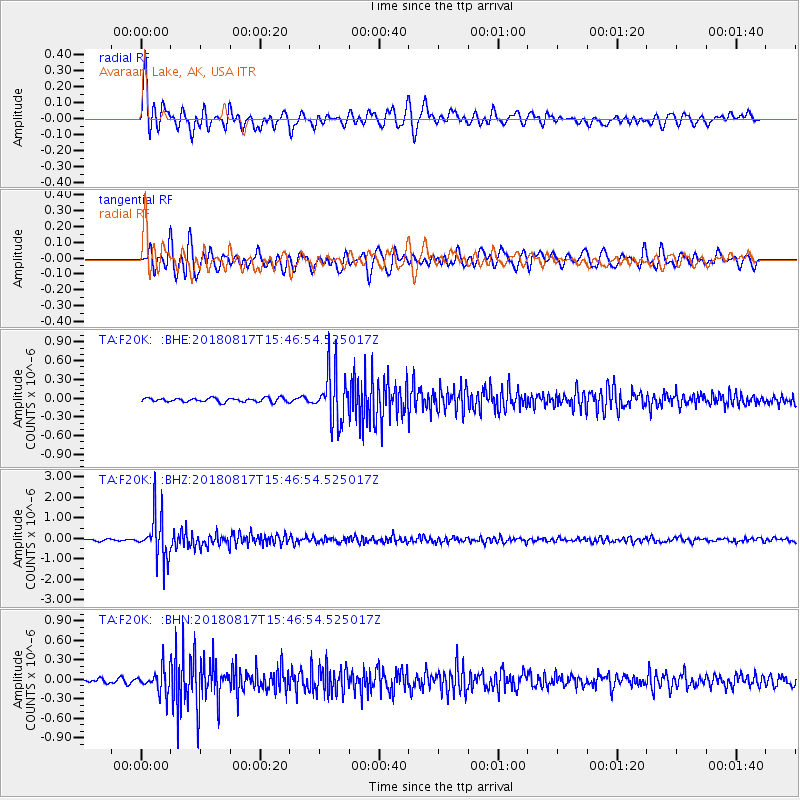
Signal To Noise
| Channel | StoN | STA | LTA |
| TA:F20K: :BHZ:20180817T15:46:54.525017Z | 31.387897 | 1.1070512E-6 | 3.5270002E-8 |
| TA:F20K: :BHN:20180817T15:46:54.525017Z | 6.6369753 | 1.796851E-7 | 2.7073341E-8 |
| TA:F20K: :BHE:20180817T15:46:54.525017Z | 13.143985 | 4.102255E-7 | 3.1210135E-8 |
| Arrivals |
| Ps | 1.5 SECOND |
| PpPs | 6.4 SECOND |
| PsPs/PpSs | 7.9 SECOND |


