You are here: Home > Network List > TA - USArray Transportable Network (new EarthScope stations) Stations List
> Station C14A Swan Lake, MT, USA > Earthquake Result Viewer
C14A Swan Lake, MT, USA - Earthquake Result Viewer

| Earthquake location: |
Primor'ye, Russia |
| Earthquake latitude/longitude: |
45.2/137.4 |
| Earthquake time(UTC): |
2008/06/29 (181) 20:53:01 GMT |
| Earthquake Depth: |
287 km |
| Earthquake Magnitude: |
5.6 MB, 6.0 MW, 5.9 MW |
| Earthquake Catalog/Contributor: |
WHDF/NEIC |
|
| Network: |
TA USArray Transportable Network (new EarthScope stations) |
| Station: |
C14A Swan Lake, MT, USA |
| Lat/Lon: |
47.77 N/113.75 W |
| Elevation: |
1173 m |
|
| Distance: |
68.4 deg |
| Az: |
43.359 deg |
| Baz: |
313.941 deg |
| Ray Param: |
0.055442724 |
| Estimated Moho Depth: |
39.25 km |
| Estimated Crust Vp/Vs: |
1.61 |
| Assumed Crust Vp: |
6.353 km/s |
| Estimated Crust Vs: |
3.946 km/s |
| Estimated Crust Poisson's Ratio: |
0.19 |
|
| Radial Match: |
84.046936 % |
| Radial Bump: |
400 |
| Transverse Match: |
78.022835 % |
| Transverse Bump: |
400 |
| SOD ConfigId: |
2504 |
| Insert Time: |
2010-03-06 14:02:28.340 +0000 |
| GWidth: |
2.5 |
| Max Bumps: |
400 |
| Tol: |
0.001 |
|
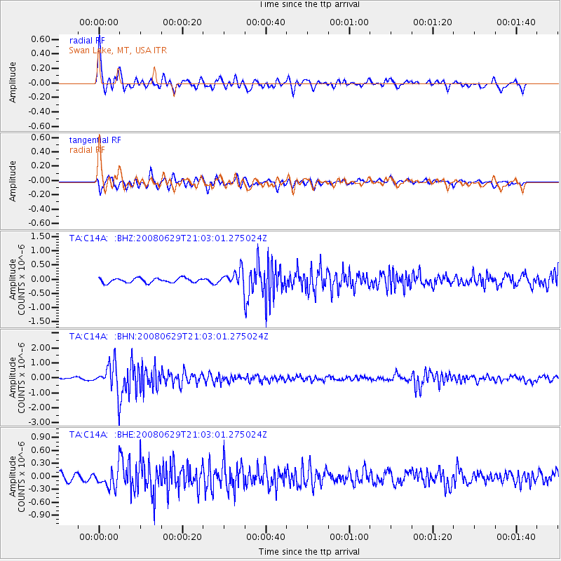
Signal To Noise
| Channel | StoN | STA | LTA |
| TA:C14A: :BHN:20080629T21:03:01.275024Z | 9.021529 | 9.909843E-7 | 1.09846596E-7 |
| TA:C14A: :BHE:20080629T21:03:01.275024Z | 1.8421891 | 2.2720207E-7 | 1.2333265E-7 |
| TA:C14A: :BHZ:20080629T21:03:01.275024Z | 3.5281157 | 2.8332587E-7 | 8.030515E-8 |
| Arrivals |
| Ps | 3.9 SECOND |
| PpPs | 15 SECOND |
| PsPs/PpSs | 19 SECOND |


