You are here: Home > Network List > TA - USArray Transportable Network (new EarthScope stations) Stations List
> Station L15K Ungalak Mountain, AK, USA > Earthquake Result Viewer
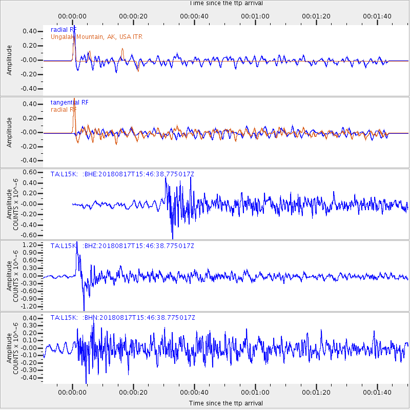
L15K Ungalak Mountain, AK, USA - Earthquake Result Viewer
*The percent match for this event was below the threshold and hence no stack was calculated.
| Earthquake location: |
Flores Sea |
| Earthquake latitude/longitude: |
-7.4/119.8 |
| Earthquake time(UTC): |
2018/08/17 (229) 15:35:02 GMT |
| Earthquake Depth: |
539 km |
| Earthquake Magnitude: |
6.5 Mww |
| Earthquake Catalog/Contributor: |
NEIC PDE/us |
|
| Network: |
TA USArray Transportable Network (new EarthScope stations) |
| Station: |
L15K Ungalak Mountain, AK, USA |
| Lat/Lon: |
61.68 N/161.49 W |
| Elevation: |
219 m |
|
| Distance: |
91.1 deg |
| Az: |
27.887 deg |
| Baz: |
256.581 deg |
| Ray Param: |
$rayparam |
*The percent match for this event was below the threshold and hence was not used in the summary stack. |
|
| Radial Match: |
77.91091 % |
| Radial Bump: |
400 |
| Transverse Match: |
55.373608 % |
| Transverse Bump: |
400 |
| SOD ConfigId: |
13570011 |
| Insert Time: |
2019-04-30 20:14:18.305 +0000 |
| GWidth: |
2.5 |
| Max Bumps: |
400 |
| Tol: |
0.001 |
|
Signal To Noise
| Channel | StoN | STA | LTA |
| TA:L15K: :BHZ:20180817T15:46:38.775017Z | 9.280218 | 5.374858E-7 | 5.7917365E-8 |
| TA:L15K: :BHN:20180817T15:46:38.775017Z | 2.1774137 | 1.2520852E-7 | 5.7503314E-8 |
| TA:L15K: :BHE:20180817T15:46:38.775017Z | 6.5926776 | 2.432895E-7 | 3.6902986E-8 |
| Arrivals |
| Ps | |
| PpPs | |
| PsPs/PpSs | |


