You are here: Home > Network List > TA - USArray Transportable Network (new EarthScope stations) Stations List
> Station M11K Mekoryuk, AK, USA > Earthquake Result Viewer
M11K Mekoryuk, AK, USA - Earthquake Result Viewer
*The percent match for this event was below the threshold and hence no stack was calculated.
| Earthquake location: |
Flores Sea |
| Earthquake latitude/longitude: |
-7.4/119.8 |
| Earthquake time(UTC): |
2018/08/17 (229) 15:35:02 GMT |
| Earthquake Depth: |
539 km |
| Earthquake Magnitude: |
6.5 Mww |
| Earthquake Catalog/Contributor: |
NEIC PDE/us |
|
| Network: |
TA USArray Transportable Network (new EarthScope stations) |
| Station: |
M11K Mekoryuk, AK, USA |
| Lat/Lon: |
60.38 N/166.20 W |
| Elevation: |
3.0 m |
|
| Distance: |
88.6 deg |
| Az: |
28.525 deg |
| Baz: |
252.464 deg |
| Ray Param: |
$rayparam |
*The percent match for this event was below the threshold and hence was not used in the summary stack. |
|
| Radial Match: |
68.27036 % |
| Radial Bump: |
400 |
| Transverse Match: |
63.09027 % |
| Transverse Bump: |
400 |
| SOD ConfigId: |
13570011 |
| Insert Time: |
2019-04-30 20:14:24.189 +0000 |
| GWidth: |
2.5 |
| Max Bumps: |
400 |
| Tol: |
0.001 |
|
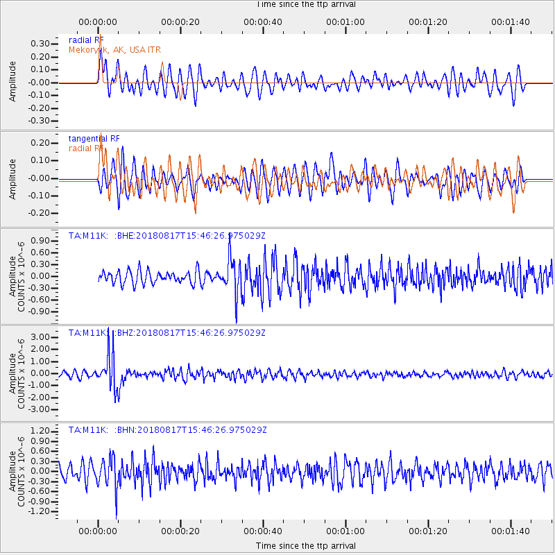
Signal To Noise
| Channel | StoN | STA | LTA |
| TA:M11K: :BHZ:20180817T15:46:26.975029Z | 7.1822033 | 1.3709367E-6 | 1.9087969E-7 |
| TA:M11K: :BHN:20180817T15:46:26.975029Z | 1.9773916 | 4.496994E-7 | 2.274205E-7 |
| TA:M11K: :BHE:20180817T15:46:26.975029Z | 2.758016 | 4.2320212E-7 | 1.534444E-7 |
| Arrivals |
| Ps | |
| PpPs | |
| PsPs/PpSs | |


