You are here: Home > Network List > TA - USArray Transportable Network (new EarthScope stations) Stations List
> Station O17K Koliganek, Bristol Bay, AK, USA > Earthquake Result Viewer
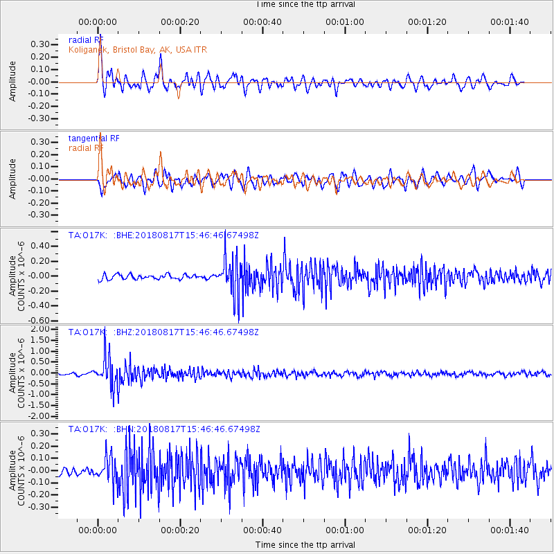
O17K Koliganek, Bristol Bay, AK, USA - Earthquake Result Viewer
*The percent match for this event was below the threshold and hence no stack was calculated.
| Earthquake location: |
Flores Sea |
| Earthquake latitude/longitude: |
-7.4/119.8 |
| Earthquake time(UTC): |
2018/08/17 (229) 15:35:02 GMT |
| Earthquake Depth: |
539 km |
| Earthquake Magnitude: |
6.5 Mww |
| Earthquake Catalog/Contributor: |
NEIC PDE/us |
|
| Network: |
TA USArray Transportable Network (new EarthScope stations) |
| Station: |
O17K Koliganek, Bristol Bay, AK, USA |
| Lat/Lon: |
59.77 N/157.09 W |
| Elevation: |
156 m |
|
| Distance: |
92.9 deg |
| Az: |
30.192 deg |
| Baz: |
260.326 deg |
| Ray Param: |
$rayparam |
*The percent match for this event was below the threshold and hence was not used in the summary stack. |
|
| Radial Match: |
79.791595 % |
| Radial Bump: |
400 |
| Transverse Match: |
70.39617 % |
| Transverse Bump: |
400 |
| SOD ConfigId: |
13570011 |
| Insert Time: |
2019-04-30 20:14:38.111 +0000 |
| GWidth: |
2.5 |
| Max Bumps: |
400 |
| Tol: |
0.001 |
|
Signal To Noise
| Channel | StoN | STA | LTA |
| TA:O17K: :BHZ:20180817T15:46:46.67498Z | 14.699731 | 7.080932E-7 | 4.8170484E-8 |
| TA:O17K: :BHN:20180817T15:46:46.67498Z | 2.9294064 | 1.0493247E-7 | 3.5820385E-8 |
| TA:O17K: :BHE:20180817T15:46:46.67498Z | 7.5209274 | 2.3823307E-7 | 3.1676024E-8 |
| Arrivals |
| Ps | |
| PpPs | |
| PsPs/PpSs | |


