You are here: Home > Network List > AV - Alaska Volcano Observatory Stations List
> Station PLBL Mt. Peulik Volcano, Alaska > Earthquake Result Viewer
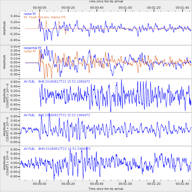
PLBL Mt. Peulik Volcano, Alaska - Earthquake Result Viewer
*The percent match for this event was below the threshold and hence no stack was calculated.
| Earthquake location: |
Volcano Islands, Japan Region |
| Earthquake latitude/longitude: |
23.5/143.3 |
| Earthquake time(UTC): |
2018/08/17 (229) 22:06:57 GMT |
| Earthquake Depth: |
18 km |
| Earthquake Magnitude: |
5.5 Mww |
| Earthquake Catalog/Contributor: |
NEIC PDE/us |
|
| Network: |
AV Alaska Volcano Observatory |
| Station: |
PLBL Mt. Peulik Volcano, Alaska |
| Lat/Lon: |
57.70 N/156.82 W |
| Elevation: |
461 m |
|
| Distance: |
54.4 deg |
| Az: |
34.808 deg |
| Baz: |
257.461 deg |
| Ray Param: |
$rayparam |
*The percent match for this event was below the threshold and hence was not used in the summary stack. |
|
| Radial Match: |
66.593414 % |
| Radial Bump: |
400 |
| Transverse Match: |
54.65714 % |
| Transverse Bump: |
400 |
| SOD ConfigId: |
13570011 |
| Insert Time: |
2019-04-30 20:17:30.021 +0000 |
| GWidth: |
2.5 |
| Max Bumps: |
400 |
| Tol: |
0.001 |
|
Signal To Noise
| Channel | StoN | STA | LTA |
| AV:PLBL: :BHZ:20180817T22:15:52.298997Z | 3.7090385 | 4.000629E-7 | 1.07861624E-7 |
| AV:PLBL: :BHN:20180817T22:15:52.298997Z | 1.2674608 | 2.2929942E-7 | 1.8091244E-7 |
| AV:PLBL: :BHE:20180817T22:15:52.298997Z | 0.81932366 | 1.430614E-7 | 1.7460913E-7 |
| Arrivals |
| Ps | |
| PpPs | |
| PsPs/PpSs | |


