You are here: Home > Network List > TA - USArray Transportable Network (new EarthScope stations) Stations List
> Station C14A Swan Lake, MT, USA > Earthquake Result Viewer
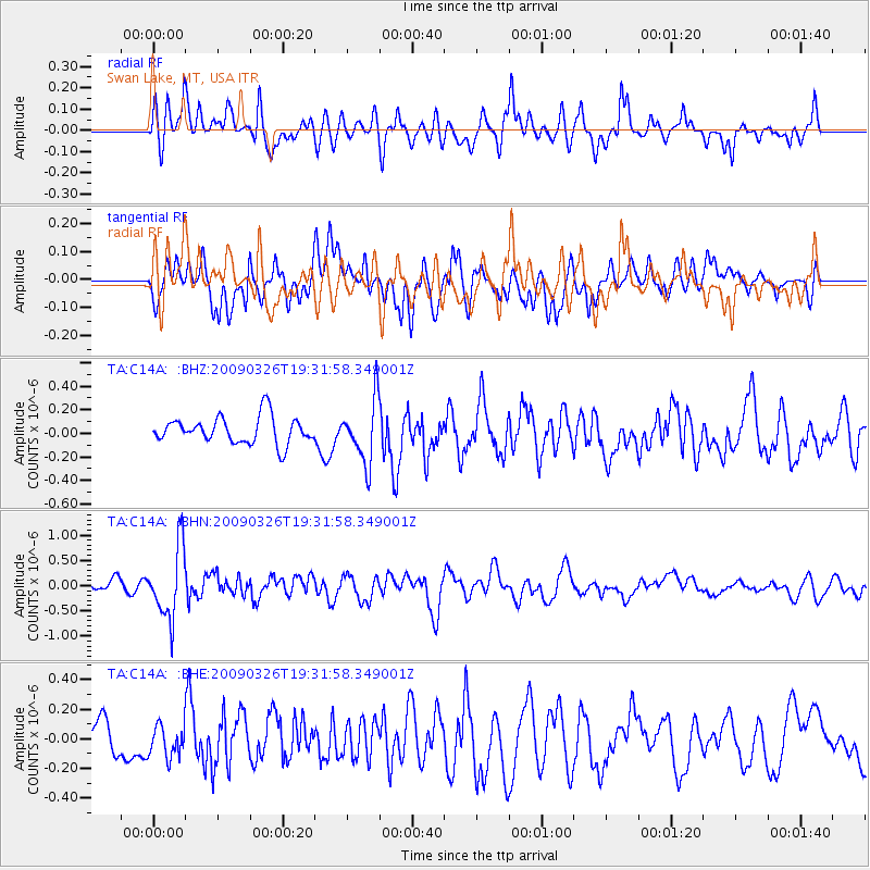
C14A Swan Lake, MT, USA - Earthquake Result Viewer
*The percent match for this event was below the threshold and hence no stack was calculated.
| Earthquake location: |
Northwest Of Ryukyu Islands |
| Earthquake latitude/longitude: |
27.4/126.7 |
| Earthquake time(UTC): |
2009/03/26 (085) 19:19:59 GMT |
| Earthquake Depth: |
160 km |
| Earthquake Magnitude: |
5.6 MB, 5.9 MW, 5.9 MW |
| Earthquake Catalog/Contributor: |
WHDF/NEIC |
|
| Network: |
TA USArray Transportable Network (new EarthScope stations) |
| Station: |
C14A Swan Lake, MT, USA |
| Lat/Lon: |
47.77 N/113.75 W |
| Elevation: |
1173 m |
|
| Distance: |
87.6 deg |
| Az: |
35.971 deg |
| Baz: |
309.285 deg |
| Ray Param: |
$rayparam |
*The percent match for this event was below the threshold and hence was not used in the summary stack. |
|
| Radial Match: |
66.911385 % |
| Radial Bump: |
400 |
| Transverse Match: |
56.58381 % |
| Transverse Bump: |
400 |
| SOD ConfigId: |
2658 |
| Insert Time: |
2010-03-06 14:03:46.693 +0000 |
| GWidth: |
2.5 |
| Max Bumps: |
400 |
| Tol: |
0.001 |
|
Signal To Noise
| Channel | StoN | STA | LTA |
| TA:C14A: :BHN:20090326T19:31:58.349001Z | 4.9057117 | 6.9470065E-7 | 1.4161057E-7 |
| TA:C14A: :BHE:20090326T19:31:58.349001Z | 0.7477405 | 1.1008185E-7 | 1.4721932E-7 |
| TA:C14A: :BHZ:20090326T19:31:58.349001Z | 2.3034446 | 2.6389617E-7 | 1.14565886E-7 |
| Arrivals |
| Ps | |
| PpPs | |
| PsPs/PpSs | |


