You are here: Home > Network List > TA - USArray Transportable Network (new EarthScope stations) Stations List
> Station C14A Swan Lake, MT, USA > Earthquake Result Viewer
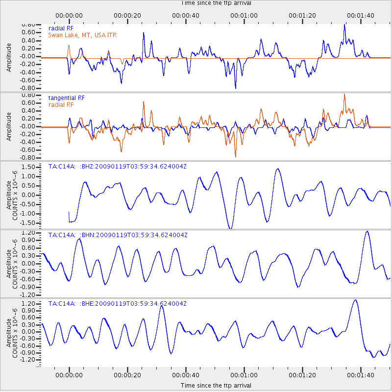
C14A Swan Lake, MT, USA - Earthquake Result Viewer
*The percent match for this event was below the threshold and hence no stack was calculated.
| Earthquake location: |
Southeast Of Loyalty Islands |
| Earthquake latitude/longitude: |
-22.5/170.8 |
| Earthquake time(UTC): |
2009/01/19 (019) 03:46:37 GMT |
| Earthquake Depth: |
35 km |
| Earthquake Magnitude: |
6.0 MW, 5.3 MB |
| Earthquake Catalog/Contributor: |
WHDF/NEIC |
|
| Network: |
TA USArray Transportable Network (new EarthScope stations) |
| Station: |
C14A Swan Lake, MT, USA |
| Lat/Lon: |
47.77 N/113.75 W |
| Elevation: |
1173 m |
|
| Distance: |
97.1 deg |
| Az: |
41.149 deg |
| Baz: |
244.449 deg |
| Ray Param: |
$rayparam |
*The percent match for this event was below the threshold and hence was not used in the summary stack. |
|
| Radial Match: |
65.36531 % |
| Radial Bump: |
400 |
| Transverse Match: |
56.299496 % |
| Transverse Bump: |
400 |
| SOD ConfigId: |
2658 |
| Insert Time: |
2010-03-06 14:03:53.438 +0000 |
| GWidth: |
2.5 |
| Max Bumps: |
400 |
| Tol: |
0.001 |
|
Signal To Noise
| Channel | StoN | STA | LTA |
| TA:C14A: :BHN:20090119T03:59:34.624004Z | 1.376695 | 6.624888E-7 | 4.812168E-7 |
| TA:C14A: :BHE:20090119T03:59:34.624004Z | 0.57734823 | 2.12681E-7 | 3.683756E-7 |
| TA:C14A: :BHZ:20090119T03:59:34.624004Z | 0.40427092 | 2.4847347E-7 | 6.146212E-7 |
| Arrivals |
| Ps | |
| PpPs | |
| PsPs/PpSs | |


