You are here: Home > Network List > TA - USArray Transportable Network (new EarthScope stations) Stations List
> Station E21K Killik River, AK, USA > Earthquake Result Viewer
E21K Killik River, AK, USA - Earthquake Result Viewer
| Earthquake location: |
Volcano Islands, Japan Region |
| Earthquake latitude/longitude: |
23.5/143.3 |
| Earthquake time(UTC): |
2018/08/17 (229) 22:06:57 GMT |
| Earthquake Depth: |
18 km |
| Earthquake Magnitude: |
5.5 Mww |
| Earthquake Catalog/Contributor: |
NEIC PDE/us |
|
| Network: |
TA USArray Transportable Network (new EarthScope stations) |
| Station: |
E21K Killik River, AK, USA |
| Lat/Lon: |
68.44 N/153.97 W |
| Elevation: |
653 m |
|
| Distance: |
58.4 deg |
| Az: |
22.675 deg |
| Baz: |
253.275 deg |
| Ray Param: |
0.062844954 |
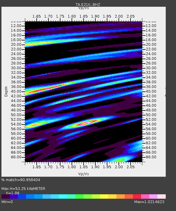
| Estimated Moho Depth: |
53.25 km |
| Estimated Crust Vp/Vs: |
1.86 |
| Assumed Crust Vp: |
6.221 km/s |
| Estimated Crust Vs: |
3.345 km/s |
| Estimated Crust Poisson's Ratio: |
0.30 |
|
| Radial Match: |
90.959404 % |
| Radial Bump: |
400 |
| Transverse Match: |
86.34826 % |
| Transverse Bump: |
400 |
| SOD ConfigId: |
13570011 |
| Insert Time: |
2019-04-30 20:22:21.061 +0000 |
| GWidth: |
2.5 |
| Max Bumps: |
400 |
| Tol: |
0.001 |
|

Signal To Noise
| Channel | StoN | STA | LTA |
| TA:E21K: :BHZ:20180817T22:16:20.725022Z | 8.063717 | 3.480855E-7 | 4.316688E-8 |
| TA:E21K: :BHN:20180817T22:16:20.725022Z | 1.3975828 | 6.753935E-8 | 4.8325827E-8 |
| TA:E21K: :BHE:20180817T22:16:20.725022Z | 2.9984267 | 1.54069E-7 | 5.1383278E-8 |
| Arrivals |
| Ps | 7.7 SECOND |
| PpPs | 23 SECOND |
| PsPs/PpSs | 31 SECOND |


