You are here: Home > Network List > TA - USArray Transportable Network (new EarthScope stations) Stations List
> Station C14A Swan Lake, MT, USA > Earthquake Result Viewer
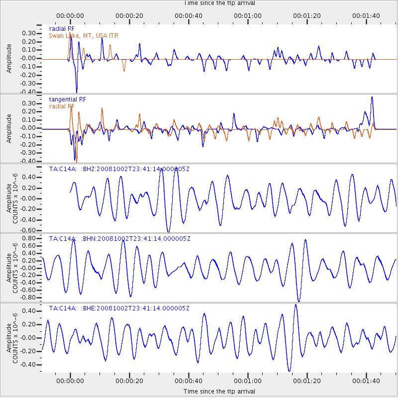
C14A Swan Lake, MT, USA - Earthquake Result Viewer
*The percent match for this event was below the threshold and hence no stack was calculated.
| Earthquake location: |
Southeast Of Loyalty Islands |
| Earthquake latitude/longitude: |
-23.0/169.9 |
| Earthquake time(UTC): |
2008/10/02 (276) 23:28:09 GMT |
| Earthquake Depth: |
10 km |
| Earthquake Magnitude: |
5.8 MB, 5.5 MS, 5.8 MW, 5.8 MW |
| Earthquake Catalog/Contributor: |
WHDF/NEIC |
|
| Network: |
TA USArray Transportable Network (new EarthScope stations) |
| Station: |
C14A Swan Lake, MT, USA |
| Lat/Lon: |
47.77 N/113.75 W |
| Elevation: |
1173 m |
|
| Distance: |
98.1 deg |
| Az: |
41.472 deg |
| Baz: |
244.751 deg |
| Ray Param: |
$rayparam |
*The percent match for this event was below the threshold and hence was not used in the summary stack. |
|
| Radial Match: |
51.01863 % |
| Radial Bump: |
400 |
| Transverse Match: |
65.093704 % |
| Transverse Bump: |
400 |
| SOD ConfigId: |
2556 |
| Insert Time: |
2010-03-06 14:04:16.660 +0000 |
| GWidth: |
2.5 |
| Max Bumps: |
400 |
| Tol: |
0.001 |
|
Signal To Noise
| Channel | StoN | STA | LTA |
| TA:C14A: :BHN:20081002T23:41:14.000005Z | 2.3076417 | 5.0307244E-7 | 2.1800282E-7 |
| TA:C14A: :BHE:20081002T23:41:14.000005Z | 0.6919734 | 9.5344966E-8 | 1.3778704E-7 |
| TA:C14A: :BHZ:20081002T23:41:14.000005Z | 1.9828632 | 4.0991515E-7 | 2.067289E-7 |
| Arrivals |
| Ps | |
| PpPs | |
| PsPs/PpSs | |


