You are here: Home > Network List > TA - USArray Transportable Network (new EarthScope stations) Stations List
> Station H27K Steamboat Mountain, AK, USA > Earthquake Result Viewer
H27K Steamboat Mountain, AK, USA - Earthquake Result Viewer
| Earthquake location: |
Volcano Islands, Japan Region |
| Earthquake latitude/longitude: |
23.5/143.3 |
| Earthquake time(UTC): |
2018/08/17 (229) 22:06:57 GMT |
| Earthquake Depth: |
18 km |
| Earthquake Magnitude: |
5.5 Mww |
| Earthquake Catalog/Contributor: |
NEIC PDE/us |
|
| Network: |
TA USArray Transportable Network (new EarthScope stations) |
| Station: |
H27K Steamboat Mountain, AK, USA |
| Lat/Lon: |
66.23 N/141.53 W |
| Elevation: |
786 m |
|
| Distance: |
62.8 deg |
| Az: |
26.143 deg |
| Baz: |
266.462 deg |
| Ray Param: |
0.059997313 |
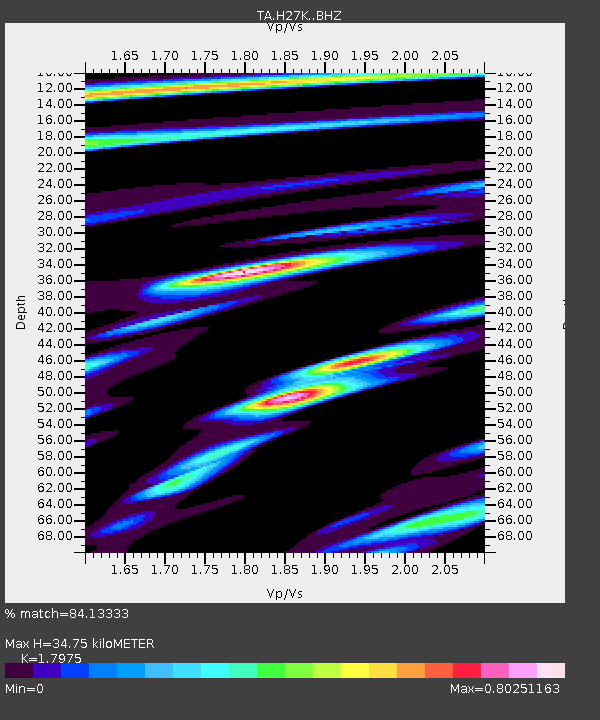
| Estimated Moho Depth: |
34.75 km |
| Estimated Crust Vp/Vs: |
1.80 |
| Assumed Crust Vp: |
6.577 km/s |
| Estimated Crust Vs: |
3.659 km/s |
| Estimated Crust Poisson's Ratio: |
0.28 |
|
| Radial Match: |
84.13333 % |
| Radial Bump: |
400 |
| Transverse Match: |
71.03218 % |
| Transverse Bump: |
400 |
| SOD ConfigId: |
13570011 |
| Insert Time: |
2019-04-30 20:22:51.579 +0000 |
| GWidth: |
2.5 |
| Max Bumps: |
400 |
| Tol: |
0.001 |
|

Signal To Noise
| Channel | StoN | STA | LTA |
| TA:H27K: :BHZ:20180817T22:16:50.374985Z | 5.925926 | 3.4976006E-7 | 5.9022007E-8 |
| TA:H27K: :BHN:20180817T22:16:50.374985Z | 1.46886 | 1.1537023E-7 | 7.854406E-8 |
| TA:H27K: :BHE:20180817T22:16:50.374985Z | 4.105075 | 2.0647032E-7 | 5.0296357E-8 |
| Arrivals |
| Ps | 4.4 SECOND |
| PpPs | 14 SECOND |
| PsPs/PpSs | 19 SECOND |


