You are here: Home > Network List > TA - USArray Transportable Network (new EarthScope stations) Stations List
> Station K29M Barlow Dome, YT, CAN > Earthquake Result Viewer
K29M Barlow Dome, YT, CAN - Earthquake Result Viewer
| Earthquake location: |
Volcano Islands, Japan Region |
| Earthquake latitude/longitude: |
23.5/143.3 |
| Earthquake time(UTC): |
2018/08/17 (229) 22:06:57 GMT |
| Earthquake Depth: |
18 km |
| Earthquake Magnitude: |
5.5 Mww |
| Earthquake Catalog/Contributor: |
NEIC PDE/us |
|
| Network: |
TA USArray Transportable Network (new EarthScope stations) |
| Station: |
K29M Barlow Dome, YT, CAN |
| Lat/Lon: |
63.84 N/137.52 W |
| Elevation: |
1367 m |
|
| Distance: |
64.4 deg |
| Az: |
28.855 deg |
| Baz: |
271.297 deg |
| Ray Param: |
0.058919676 |
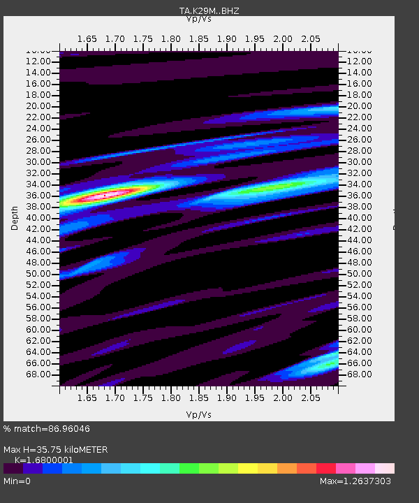
| Estimated Moho Depth: |
35.75 km |
| Estimated Crust Vp/Vs: |
1.68 |
| Assumed Crust Vp: |
6.566 km/s |
| Estimated Crust Vs: |
3.908 km/s |
| Estimated Crust Poisson's Ratio: |
0.23 |
|
| Radial Match: |
86.96046 % |
| Radial Bump: |
400 |
| Transverse Match: |
74.951515 % |
| Transverse Bump: |
400 |
| SOD ConfigId: |
13570011 |
| Insert Time: |
2019-04-30 20:23:11.367 +0000 |
| GWidth: |
2.5 |
| Max Bumps: |
400 |
| Tol: |
0.001 |
|
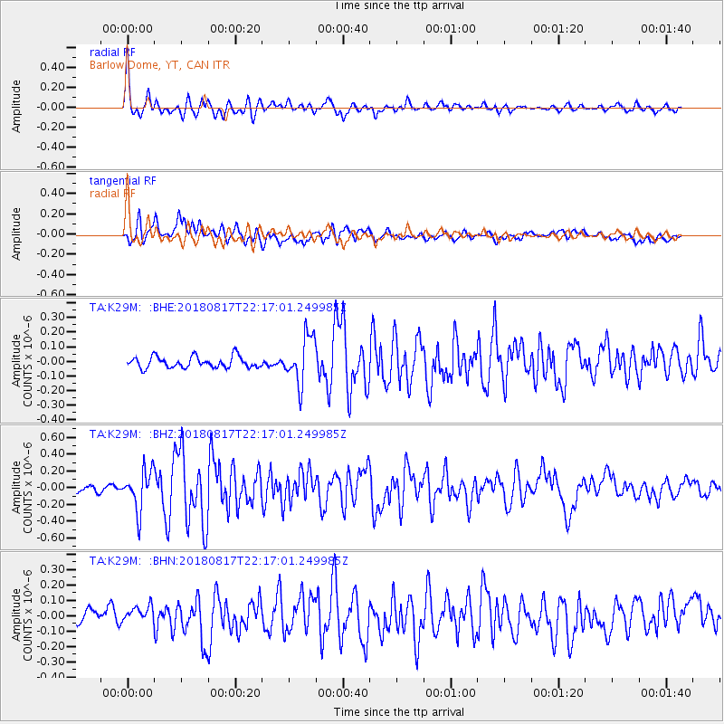
Signal To Noise
| Channel | StoN | STA | LTA |
| TA:K29M: :BHZ:20180817T22:17:01.249985Z | 4.3171663 | 2.4199355E-7 | 5.6053796E-8 |
| TA:K29M: :BHN:20180817T22:17:01.249985Z | 1.1450162 | 6.104388E-8 | 5.3312675E-8 |
| TA:K29M: :BHE:20180817T22:17:01.249985Z | 4.240139 | 1.6336804E-7 | 3.8528935E-8 |
| Arrivals |
| Ps | 3.9 SECOND |
| PpPs | 14 SECOND |
| PsPs/PpSs | 18 SECOND |


