You are here: Home > Network List > TA - USArray Transportable Network (new EarthScope stations) Stations List
> Station Q17K Contact Creek, Katmai, AK, USA > Earthquake Result Viewer
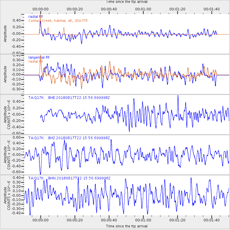
Q17K Contact Creek, Katmai, AK, USA - Earthquake Result Viewer
*The percent match for this event was below the threshold and hence no stack was calculated.
| Earthquake location: |
Volcano Islands, Japan Region |
| Earthquake latitude/longitude: |
23.5/143.3 |
| Earthquake time(UTC): |
2018/08/17 (229) 22:06:57 GMT |
| Earthquake Depth: |
18 km |
| Earthquake Magnitude: |
5.5 Mww |
| Earthquake Catalog/Contributor: |
NEIC PDE/us |
|
| Network: |
TA USArray Transportable Network (new EarthScope stations) |
| Station: |
Q17K Contact Creek, Katmai, AK, USA |
| Lat/Lon: |
58.26 N/155.89 W |
| Elevation: |
1165 m |
|
| Distance: |
55.0 deg |
| Az: |
34.26 deg |
| Baz: |
257.936 deg |
| Ray Param: |
$rayparam |
*The percent match for this event was below the threshold and hence was not used in the summary stack. |
|
| Radial Match: |
60.578854 % |
| Radial Bump: |
400 |
| Transverse Match: |
60.333427 % |
| Transverse Bump: |
400 |
| SOD ConfigId: |
13570011 |
| Insert Time: |
2019-04-30 20:23:51.470 +0000 |
| GWidth: |
2.5 |
| Max Bumps: |
400 |
| Tol: |
0.001 |
|
Signal To Noise
| Channel | StoN | STA | LTA |
| TA:Q17K: :BHZ:20180817T22:15:56.699998Z | 3.1571372 | 2.702395E-7 | 8.5596376E-8 |
| TA:Q17K: :BHN:20180817T22:15:56.699998Z | 1.6311927 | 1.9287471E-7 | 1.1824152E-7 |
| TA:Q17K: :BHE:20180817T22:15:56.699998Z | 1.5827364 | 1.4553407E-7 | 9.195093E-8 |
| Arrivals |
| Ps | |
| PpPs | |
| PsPs/PpSs | |


