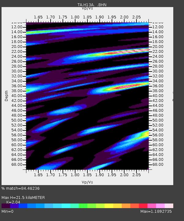
H13A Challis, ID, USA - Earthquake Result Viewer
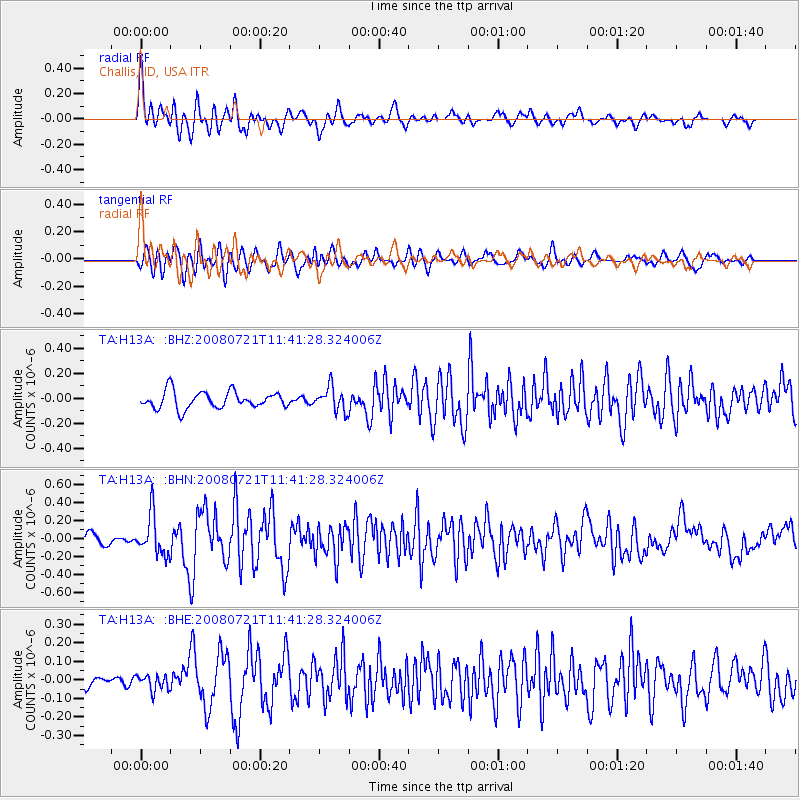
Earthquake location: Off East Coast Of Honshu, Japan
Earthquake latitude/longitude: 37.2/142.1
Earthquake time(UTC): 2008/07/21 (203) 11:30:29 GMT
Earthquake Depth: 22 km
Earthquake Magnitude: 5.7 MB, 5.6 MS, 6.0 MW, 5.9 MW
Earthquake Catalog/Contributor: WHDF/NEIC
Network: TA USArray Transportable Network (new EarthScope stations)
Station: H13A Challis, ID, USA
Lat/Lon: 44.56 N/114.25 W
Elevation: 1563 m
Distance: 73.4 deg
Az: 46.444 deg
Baz: 305.936 deg
Ray Param: 0.05300643
Estimated Moho Depth: 21.5 km
Estimated Crust Vp/Vs: 2.04
Assumed Crust Vp: 6.577 km/s
Estimated Crust Vs: 3.224 km/s
Estimated Crust Poisson's Ratio: 0.34
Radial Match: 84.46236 %
Radial Bump: 400
Transverse Match: 74.53039 %
Transverse Bump: 400
SOD ConfigId: 2504
Insert Time: 2010-03-06 14:04:49.240 +0000
GWidth: 2.5
Max Bumps: 400
Tol: 0.001

Signal To Noise

ChannelStoNSTALTA
TA:H13A: :BHN:20080721T11:41:28.324006Z4.82957032.2005261E-74.55636E-8
TA:H13A: :BHE:20080721T11:41:28.324006Z0.893598854.1926583E-84.6918796E-8
TA:H13A: :BHZ:20080721T11:41:28.324006Z1.40993249.6135935E-86.818478E-8
Arrivals
Ps3.5 SECOND
PpPs9.6 SECOND
PsPs/PpSs13 SECOND