You are here: Home > Network List > XO18 - AACE: Alaska Amphibious Community seismic Experimen Stations List
> Station EP16 Levelock, AK > Earthquake Result Viewer
EP16 Levelock, AK - Earthquake Result Viewer
| Earthquake location: |
Volcano Islands, Japan Region |
| Earthquake latitude/longitude: |
23.5/143.3 |
| Earthquake time(UTC): |
2018/08/17 (229) 22:06:57 GMT |
| Earthquake Depth: |
18 km |
| Earthquake Magnitude: |
5.5 Mww |
| Earthquake Catalog/Contributor: |
NEIC PDE/us |
|
| Network: |
XO AACE: Alaska Amphibious Community seismic Experimen |
| Station: |
EP16 Levelock, AK |
| Lat/Lon: |
59.11 N/156.86 W |
| Elevation: |
46 m |
|
| Distance: |
54.7 deg |
| Az: |
33.108 deg |
| Baz: |
256.445 deg |
| Ray Param: |
0.06525595 |
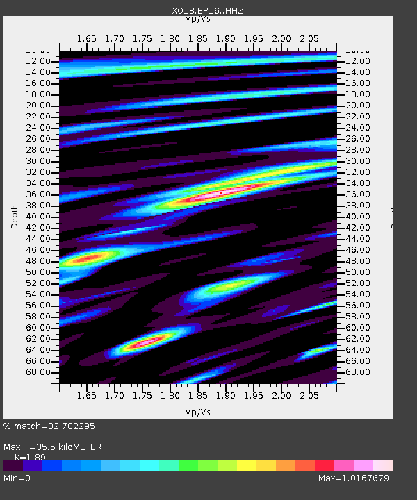
| Estimated Moho Depth: |
35.5 km |
| Estimated Crust Vp/Vs: |
1.89 |
| Assumed Crust Vp: |
6.276 km/s |
| Estimated Crust Vs: |
3.321 km/s |
| Estimated Crust Poisson's Ratio: |
0.31 |
|
| Radial Match: |
82.782295 % |
| Radial Bump: |
400 |
| Transverse Match: |
75.68271 % |
| Transverse Bump: |
400 |
| SOD ConfigId: |
13570011 |
| Insert Time: |
2019-04-30 20:25:38.023 +0000 |
| GWidth: |
2.5 |
| Max Bumps: |
400 |
| Tol: |
0.001 |
|

Signal To Noise
| Channel | StoN | STA | LTA |
| XO:EP16: :HHZ:20180817T22:15:54.480027Z | 2.288682 | 6.324877E-7 | 2.7635454E-7 |
| XO:EP16: :HHN:20180817T22:15:54.480027Z | 1.187 | 3.6972682E-7 | 3.1148002E-7 |
| XO:EP16: :HHE:20180817T22:15:54.480027Z | 1.4137028 | 4.275744E-7 | 3.0245E-7 |
| Arrivals |
| Ps | 5.3 SECOND |
| PpPs | 16 SECOND |
| PsPs/PpSs | 21 SECOND |


