You are here: Home > Network List > TA - USArray Transportable Network (new EarthScope stations) Stations List
> Station H13A Challis, ID, USA > Earthquake Result Viewer
H13A Challis, ID, USA - Earthquake Result Viewer

| Earthquake location: |
Kuril Islands |
| Earthquake latitude/longitude: |
51.0/157.6 |
| Earthquake time(UTC): |
2008/07/24 (206) 01:43:16 GMT |
| Earthquake Depth: |
27 km |
| Earthquake Magnitude: |
6.0 MB, 6.0 MS, 6.2 MW, 6.2 MW |
| Earthquake Catalog/Contributor: |
WHDF/NEIC |
|
| Network: |
TA USArray Transportable Network (new EarthScope stations) |
| Station: |
H13A Challis, ID, USA |
| Lat/Lon: |
44.56 N/114.25 W |
| Elevation: |
1563 m |
|
| Distance: |
56.2 deg |
| Az: |
59.287 deg |
| Baz: |
310.49 deg |
| Ray Param: |
0.064252906 |
| Estimated Moho Depth: |
21.5 km |
| Estimated Crust Vp/Vs: |
2.10 |
| Assumed Crust Vp: |
6.577 km/s |
| Estimated Crust Vs: |
3.136 km/s |
| Estimated Crust Poisson's Ratio: |
0.35 |
|
| Radial Match: |
91.23079 % |
| Radial Bump: |
400 |
| Transverse Match: |
90.79915 % |
| Transverse Bump: |
400 |
| SOD ConfigId: |
2504 |
| Insert Time: |
2010-03-06 14:04:52.220 +0000 |
| GWidth: |
2.5 |
| Max Bumps: |
400 |
| Tol: |
0.001 |
|
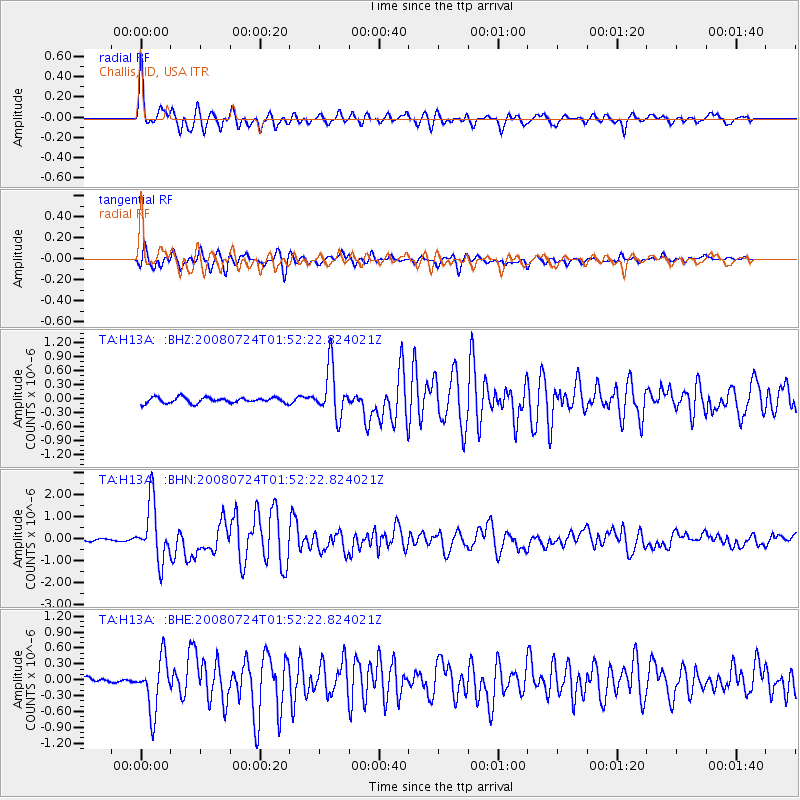
Signal To Noise
| Channel | StoN | STA | LTA |
| TA:H13A: :BHN:20080724T01:52:22.824021Z | 23.088858 | 1.3050204E-6 | 5.6521657E-8 |
| TA:H13A: :BHE:20080724T01:52:22.824021Z | 10.1168785 | 4.962003E-7 | 4.9046776E-8 |
| TA:H13A: :BHZ:20080724T01:52:22.824021Z | 8.517155 | 5.1939236E-7 | 6.098191E-8 |
| Arrivals |
| Ps | 3.8 SECOND |
| PpPs | 9.7 SECOND |
| PsPs/PpSs | 13 SECOND |


