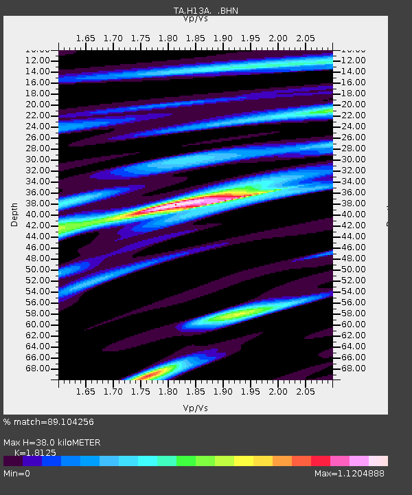
H13A Challis, ID, USA - Earthquake Result Viewer

Earthquake location: Near Coast Of Chiapas, Mexico
Earthquake latitude/longitude: 14.4/-92.4
Earthquake time(UTC): 2008/10/16 (290) 19:41:25 GMT
Earthquake Depth: 24 km
Earthquake Magnitude: 6.1 MB, 6.6 MS, 6.7 MW, 6.6 MW
Earthquake Catalog/Contributor: WHDF/NEIC
Network: TA USArray Transportable Network (new EarthScope stations)
Station: H13A Challis, ID, USA
Lat/Lon: 44.56 N/114.25 W
Elevation: 1563 m
Distance: 35.3 deg
Az: 332.565 deg
Baz: 141.354 deg
Ray Param: 0.077240326
Estimated Moho Depth: 38.0 km
Estimated Crust Vp/Vs: 1.81
Assumed Crust Vp: 6.577 km/s
Estimated Crust Vs: 3.629 km/s
Estimated Crust Poisson's Ratio: 0.28
Radial Match: 89.104256 %
Radial Bump: 400
Transverse Match: 80.75954 %
Transverse Bump: 400
SOD ConfigId: 2556
Insert Time: 2010-03-06 14:05:06.402 +0000
GWidth: 2.5
Max Bumps: 400
Tol: 0.001

Signal To Noise

ChannelStoNSTALTA
TA:H13A: :BHN:20081016T19:47:48.450011Z27.178844.00379E-61.4731275E-7
TA:H13A: :BHE:20081016T19:47:48.450011Z12.1163241.8062607E-61.4907663E-7
TA:H13A: :BHZ:20081016T19:47:48.450011Z15.37910651.3022174E-68.467445E-8
Arrivals
Ps5.1 SECOND
PpPs15 SECOND
PsPs/PpSs20 SECOND