You are here: Home > Network List > TA - USArray Transportable Network (new EarthScope stations) Stations List
> Station H13A Challis, ID, USA > Earthquake Result Viewer
H13A Challis, ID, USA - Earthquake Result Viewer

| Earthquake location: |
Svalbard Region |
| Earthquake latitude/longitude: |
77.1/18.6 |
| Earthquake time(UTC): |
2008/02/21 (052) 02:46:17 GMT |
| Earthquake Depth: |
10 km |
| Earthquake Magnitude: |
5.7 MB, 5.9 MS, 6.1 MW, 6.0 MW |
| Earthquake Catalog/Contributor: |
WHDF/NEIC |
|
| Network: |
TA USArray Transportable Network (new EarthScope stations) |
| Station: |
H13A Challis, ID, USA |
| Lat/Lon: |
44.56 N/114.25 W |
| Elevation: |
1563 m |
|
| Distance: |
55.1 deg |
| Az: |
320.272 deg |
| Baz: |
11.607 deg |
| Ray Param: |
0.06501195 |
| Estimated Moho Depth: |
58.25 km |
| Estimated Crust Vp/Vs: |
2.05 |
| Assumed Crust Vp: |
6.577 km/s |
| Estimated Crust Vs: |
3.208 km/s |
| Estimated Crust Poisson's Ratio: |
0.34 |
|
| Radial Match: |
84.54017 % |
| Radial Bump: |
400 |
| Transverse Match: |
72.63481 % |
| Transverse Bump: |
400 |
| SOD ConfigId: |
2564 |
| Insert Time: |
2010-03-06 14:05:18.788 +0000 |
| GWidth: |
2.5 |
| Max Bumps: |
400 |
| Tol: |
0.001 |
|
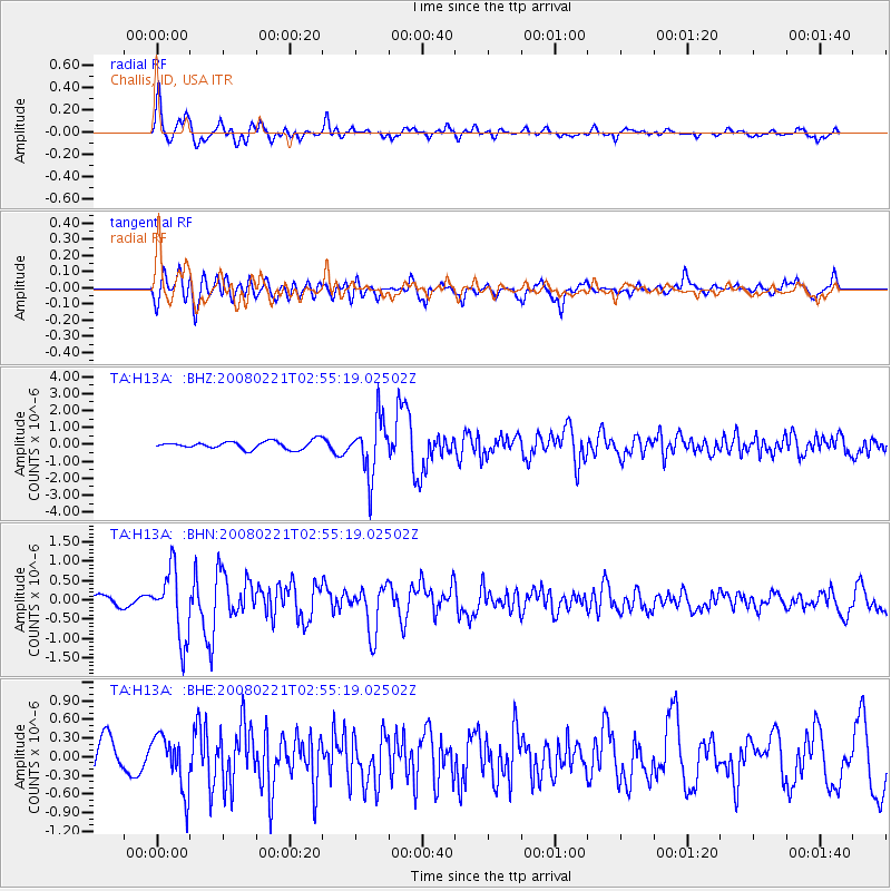
Signal To Noise
| Channel | StoN | STA | LTA |
| TA:H13A: :BHN:20080221T02:55:19.02502Z | 4.8563843 | 8.8664797E-7 | 1.8257369E-7 |
| TA:H13A: :BHE:20080221T02:55:19.02502Z | 1.9809101 | 4.3593826E-7 | 2.2006968E-7 |
| TA:H13A: :BHZ:20080221T02:55:19.02502Z | 7.1180983 | 1.6600306E-6 | 2.3321266E-7 |
| Arrivals |
| Ps | 9.8 SECOND |
| PpPs | 26 SECOND |
| PsPs/PpSs | 36 SECOND |


