You are here: Home > Network List > TA - USArray Transportable Network (new EarthScope stations) Stations List
> Station H13A Challis, ID, USA > Earthquake Result Viewer
H13A Challis, ID, USA - Earthquake Result Viewer
| Earthquake location: |
South Of Fiji Islands |
| Earthquake latitude/longitude: |
-25.8/179.5 |
| Earthquake time(UTC): |
2007/10/16 (289) 21:05:43 GMT |
| Earthquake Depth: |
509 km |
| Earthquake Magnitude: |
6.2 MB, 6.6 MW, 6.5 MW |
| Earthquake Catalog/Contributor: |
WHDF/NEIC |
|
| Network: |
TA USArray Transportable Network (new EarthScope stations) |
| Station: |
H13A Challis, ID, USA |
| Lat/Lon: |
44.56 N/114.25 W |
| Elevation: |
1563 m |
|
| Distance: |
92.4 deg |
| Az: |
40.897 deg |
| Baz: |
235.671 deg |
| Ray Param: |
0.04107877 |
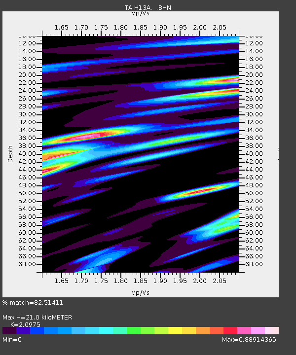
| Estimated Moho Depth: |
21.0 km |
| Estimated Crust Vp/Vs: |
2.10 |
| Assumed Crust Vp: |
6.577 km/s |
| Estimated Crust Vs: |
3.136 km/s |
| Estimated Crust Poisson's Ratio: |
0.35 |
|
| Radial Match: |
82.51411 % |
| Radial Bump: |
400 |
| Transverse Match: |
70.96888 % |
| Transverse Bump: |
400 |
| SOD ConfigId: |
2564 |
| Insert Time: |
2010-03-06 14:05:44.541 +0000 |
| GWidth: |
2.5 |
| Max Bumps: |
400 |
| Tol: |
0.001 |
|
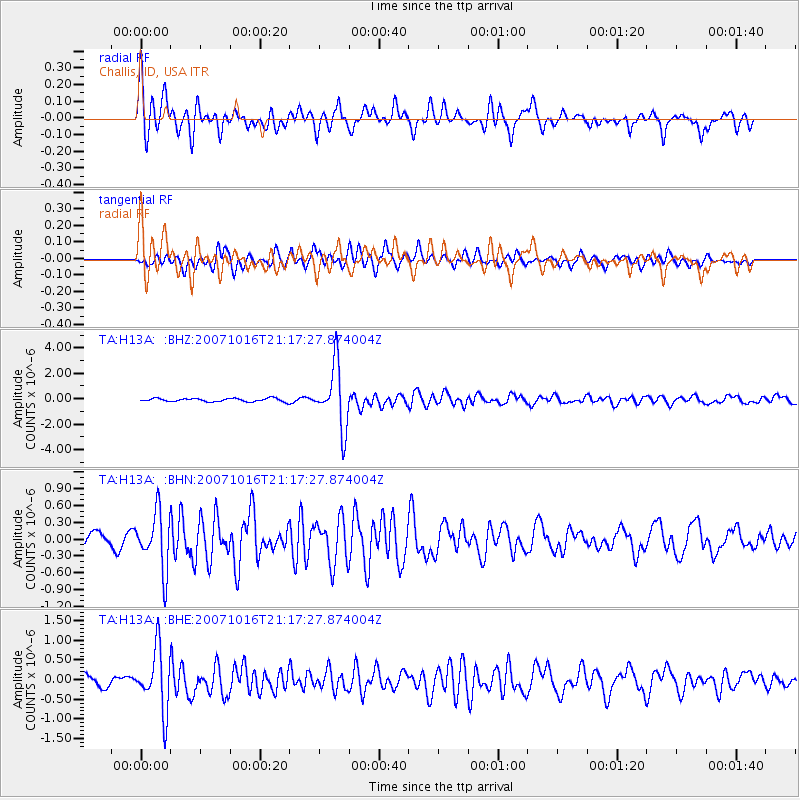
Signal To Noise
| Channel | StoN | STA | LTA |
| TA:H13A: :BHN:20071016T21:17:27.874004Z | 3.707714 | 5.105457E-7 | 1.3769824E-7 |
| TA:H13A: :BHE:20071016T21:17:27.874004Z | 4.4783826 | 7.793646E-7 | 1.7402814E-7 |
| TA:H13A: :BHZ:20071016T21:17:27.874004Z | 18.867716 | 2.4311573E-6 | 1.2885276E-7 |
| Arrivals |
| Ps | 3.6 SECOND |
| PpPs | 9.7 SECOND |
| PsPs/PpSs | 13 SECOND |


