You are here: Home > Network List > TA - USArray Transportable Network (new EarthScope stations) Stations List
> Station H13A Challis, ID, USA > Earthquake Result Viewer
H13A Challis, ID, USA - Earthquake Result Viewer
| Earthquake location: |
Near Coast Of Peru |
| Earthquake latitude/longitude: |
-14.3/-76.1 |
| Earthquake time(UTC): |
2007/08/16 (228) 05:16:56 GMT |
| Earthquake Depth: |
23 km |
| Earthquake Magnitude: |
5.8 MB, 6.1 MS, 6.3 MW, 6.2 ML |
| Earthquake Catalog/Contributor: |
WHDF/NEIC |
|
| Network: |
TA USArray Transportable Network (new EarthScope stations) |
| Station: |
H13A Challis, ID, USA |
| Lat/Lon: |
44.56 N/114.25 W |
| Elevation: |
1563 m |
|
| Distance: |
68.1 deg |
| Az: |
331.588 deg |
| Baz: |
139.809 deg |
| Ray Param: |
0.056525774 |
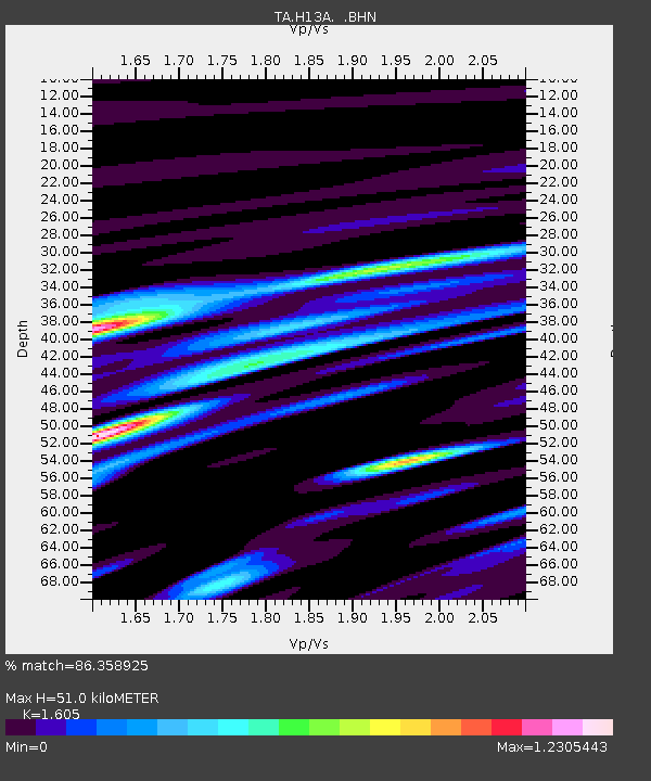
| Estimated Moho Depth: |
51.0 km |
| Estimated Crust Vp/Vs: |
1.61 |
| Assumed Crust Vp: |
6.577 km/s |
| Estimated Crust Vs: |
4.098 km/s |
| Estimated Crust Poisson's Ratio: |
0.18 |
|
| Radial Match: |
86.358925 % |
| Radial Bump: |
400 |
| Transverse Match: |
67.12807 % |
| Transverse Bump: |
400 |
| SOD ConfigId: |
2564 |
| Insert Time: |
2010-03-06 14:06:03.236 +0000 |
| GWidth: |
2.5 |
| Max Bumps: |
400 |
| Tol: |
0.001 |
|
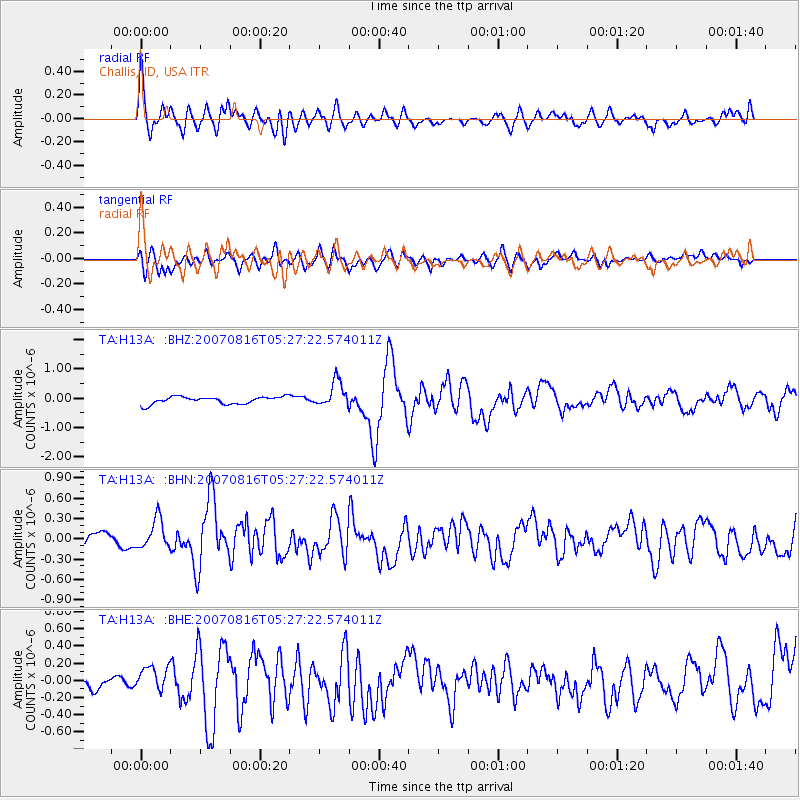
Signal To Noise
| Channel | StoN | STA | LTA |
| TA:H13A: :BHN:20070816T05:27:22.574011Z | 2.3085854 | 2.1784572E-7 | 9.4363294E-8 |
| TA:H13A: :BHE:20070816T05:27:22.574011Z | 2.499879 | 1.5462994E-7 | 6.1854976E-8 |
| TA:H13A: :BHZ:20070816T05:27:22.574011Z | 3.482125 | 4.3705435E-7 | 1.2551368E-7 |
| Arrivals |
| Ps | 4.9 SECOND |
| PpPs | 19 SECOND |
| PsPs/PpSs | 24 SECOND |


