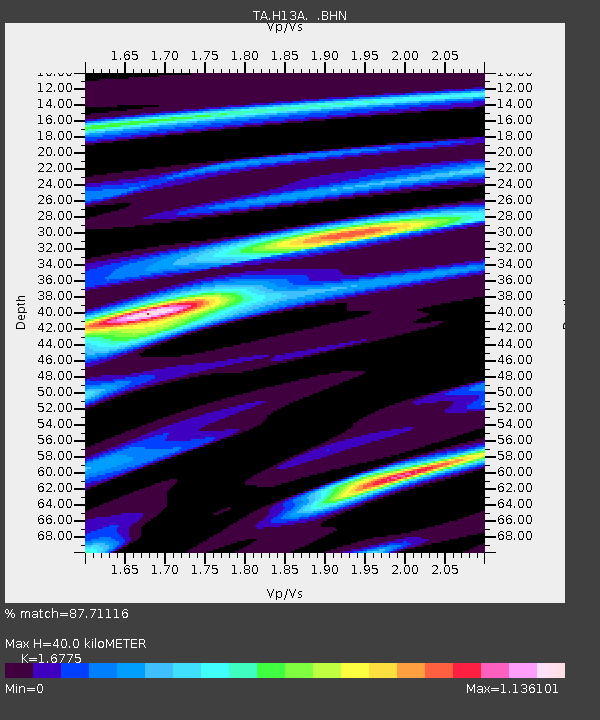
H13A Challis, ID, USA - Earthquake Result Viewer
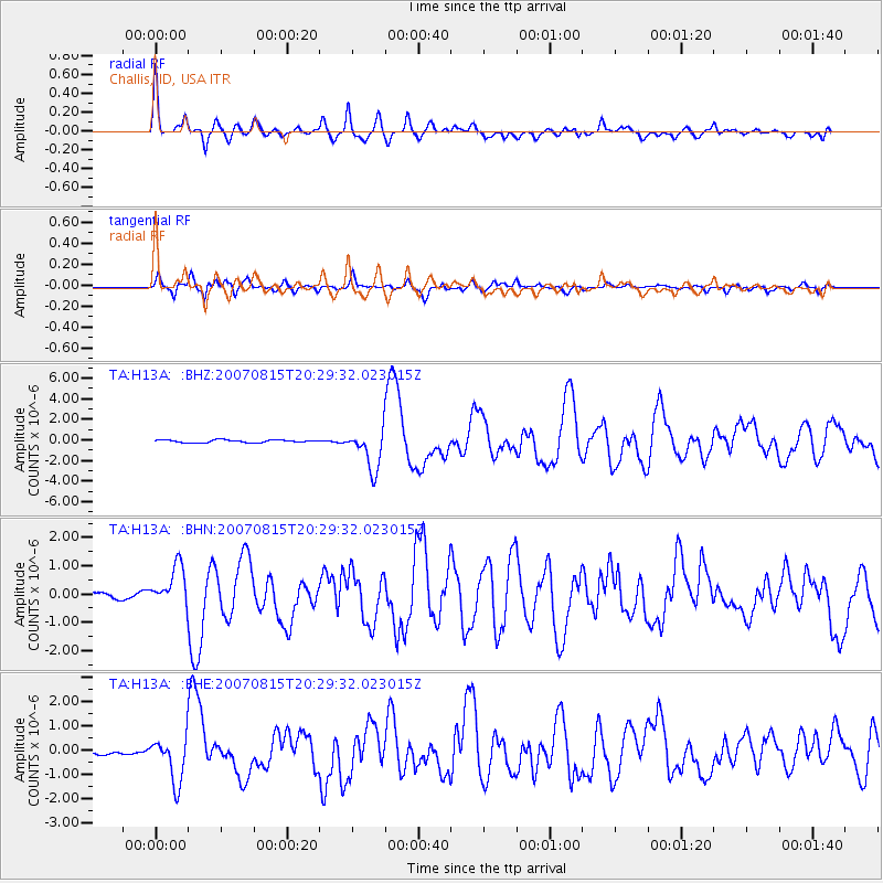
Earthquake location: Andreanof Islands, Aleutian Is.
Earthquake latitude/longitude: 50.3/-177.5
Earthquake time(UTC): 2007/08/15 (227) 20:22:11 GMT
Earthquake Depth: 9.0 km
Earthquake Magnitude: 6.3 MB, 6.2 MS, 6.4 MW, 5.9 ML
Earthquake Catalog/Contributor: WHDF/NEIC
Network: TA USArray Transportable Network (new EarthScope stations)
Station: H13A Challis, ID, USA
Lat/Lon: 44.56 N/114.25 W
Elevation: 1563 m
Distance: 42.0 deg
Az: 72.471 deg
Baz: 301.228 deg
Ray Param: 0.07341109
Estimated Moho Depth: 40.0 km
Estimated Crust Vp/Vs: 1.68
Assumed Crust Vp: 6.577 km/s
Estimated Crust Vs: 3.921 km/s
Estimated Crust Poisson's Ratio: 0.22
Radial Match: 87.71116 %
Radial Bump: 400
Transverse Match: 82.4827 %
Transverse Bump: 400
SOD ConfigId: 2564
Insert Time: 2010-03-06 14:06:10.204 +0000
GWidth: 2.5
Max Bumps: 400
Tol: 0.001

Signal To Noise

ChannelStoNSTALTA
TA:H13A: :BHN:20070815T20:29:32.023015Z6.27382667.133169E-71.1369726E-7
TA:H13A: :BHE:20070815T20:29:32.023015Z9.8888439.225766E-79.3294695E-8
TA:H13A: :BHZ:20070815T20:29:32.023015Z14.3543141.973214E-61.3746487E-7
Arrivals
Ps4.4 SECOND
PpPs15 SECOND
PsPs/PpSs20 SECOND