H13A Challis, ID, USA - Earthquake Result Viewer
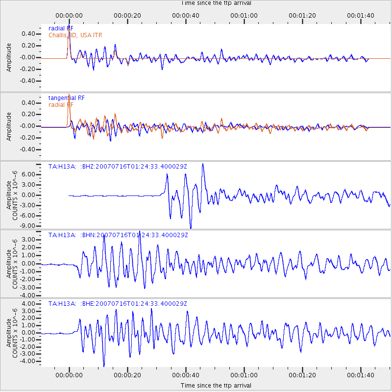
Earthquake location: Near West Coast Of Honshu, Japan
Earthquake latitude/longitude: 37.5/138.4
Earthquake time(UTC): 2007/07/16 (197) 01:13:22 GMT
Earthquake Depth: 12 km
Earthquake Magnitude: 6.5 MB, 6.4 MS, 6.6 MW, 6.5 MW
Earthquake Catalog/Contributor: WHDF/NEIC
Network: TA USArray Transportable Network (new EarthScope stations)
Station: H13A Challis, ID, USA
Lat/Lon: 44.56 N/114.25 W
Elevation: 1563 m
Distance: 75.2 deg
Az: 44.9 deg
Baz: 308.279 deg
Ray Param: 0.051817432
Estimated Moho Depth: 59.25 km
Estimated Crust Vp/Vs: 1.81
Assumed Crust Vp: 6.577 km/s
Estimated Crust Vs: 3.629 km/s
Estimated Crust Poisson's Ratio: 0.28
Radial Match: 94.17472 %
Radial Bump: 400
Transverse Match: 91.46684 %
Transverse Bump: 400
SOD ConfigId: 2564
Insert Time: 2010-03-06 14:06:32.923 +0000
GWidth: 2.5
Max Bumps: 400
Tol: 0.001

Signal To Noise

ChannelStoNSTALTA
TA:H13A: :BHN:20070716T01:24:33.400029Z17.8015566.679009E-73.7519243E-8
TA:H13A: :BHE:20070716T01:24:33.400029Z38.7508439.2918714E-72.3978501E-8
TA:H13A: :BHZ:20070716T01:24:33.400029Z46.3813672.6828575E-65.7843433E-8
Arrivals
Ps7.6 SECOND
PpPs25 SECOND
PsPs/PpSs32 SECOND