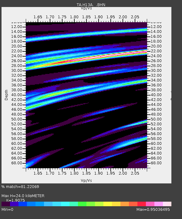
H13A Challis, ID, USA - Earthquake Result Viewer
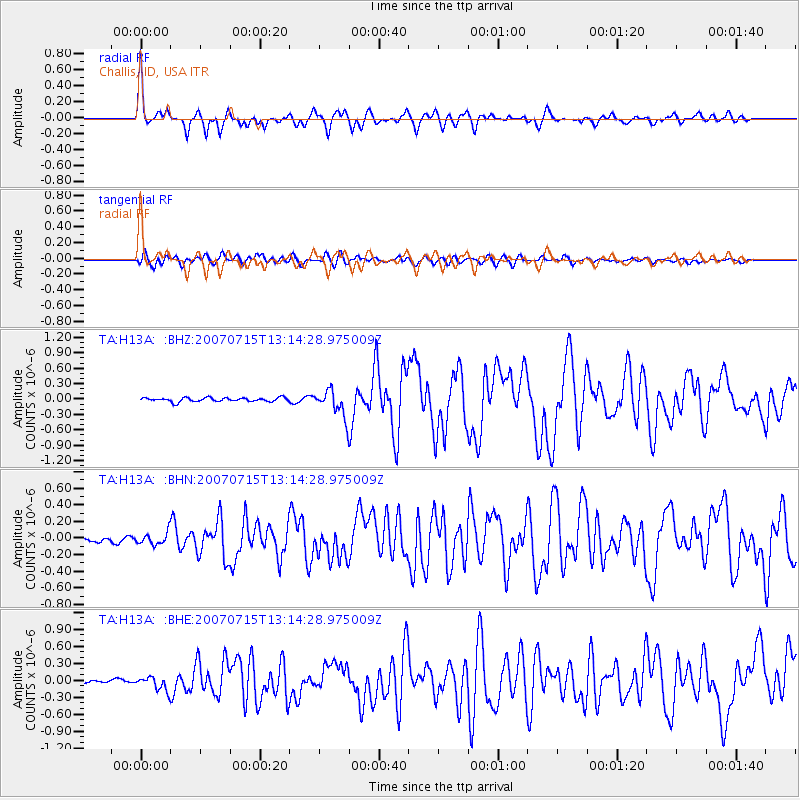
Earthquake location: Fox Islands, Aleutian Islands
Earthquake latitude/longitude: 52.5/-168.0
Earthquake time(UTC): 2007/07/15 (196) 13:08:00 GMT
Earthquake Depth: 10 km
Earthquake Magnitude: 5.8 MB, 5.9 MS, 6.1 MW, 6.0 MW
Earthquake Catalog/Contributor: WHDF/NEIC
Network: TA USArray Transportable Network (new EarthScope stations)
Station: H13A Challis, ID, USA
Lat/Lon: 44.56 N/114.25 W
Elevation: 1563 m
Distance: 35.8 deg
Az: 80.777 deg
Baz: 302.373 deg
Ray Param: 0.07705231
Estimated Moho Depth: 24.0 km
Estimated Crust Vp/Vs: 1.91
Assumed Crust Vp: 6.577 km/s
Estimated Crust Vs: 3.448 km/s
Estimated Crust Poisson's Ratio: 0.31
Radial Match: 81.22069 %
Radial Bump: 400
Transverse Match: 74.33783 %
Transverse Bump: 400
SOD ConfigId: 2564
Insert Time: 2010-03-06 14:06:34.657 +0000
GWidth: 2.5
Max Bumps: 400
Tol: 0.001

Signal To Noise

ChannelStoNSTALTA
TA:H13A: :BHN:20070715T13:14:28.975009Z2.11894427.180435E-83.3886856E-8
TA:H13A: :BHE:20070715T13:14:28.975009Z3.41190151.2039757E-73.5287528E-8
TA:H13A: :BHZ:20070715T13:14:28.975009Z6.98824932.6735506E-73.8257802E-8
Arrivals
Ps3.6 SECOND
PpPs9.9 SECOND
PsPs/PpSs13 SECOND