You are here: Home > Network List > TA - USArray Transportable Network (new EarthScope stations) Stations List
> Station H13A Challis, ID, USA > Earthquake Result Viewer
H13A Challis, ID, USA - Earthquake Result Viewer
| Earthquake location: |
Vanuatu Islands |
| Earthquake latitude/longitude: |
-15.4/168.6 |
| Earthquake time(UTC): |
2007/07/15 (196) 09:27:34 GMT |
| Earthquake Depth: |
8.0 km |
| Earthquake Magnitude: |
6.0 MB, 5.8 MS, 6.1 MW, 6.0 MW |
| Earthquake Catalog/Contributor: |
WHDF/NEIC |
|
| Network: |
TA USArray Transportable Network (new EarthScope stations) |
| Station: |
H13A Challis, ID, USA |
| Lat/Lon: |
44.56 N/114.25 W |
| Elevation: |
1563 m |
|
| Distance: |
91.8 deg |
| Az: |
44.206 deg |
| Baz: |
250.206 deg |
| Ray Param: |
0.041559283 |
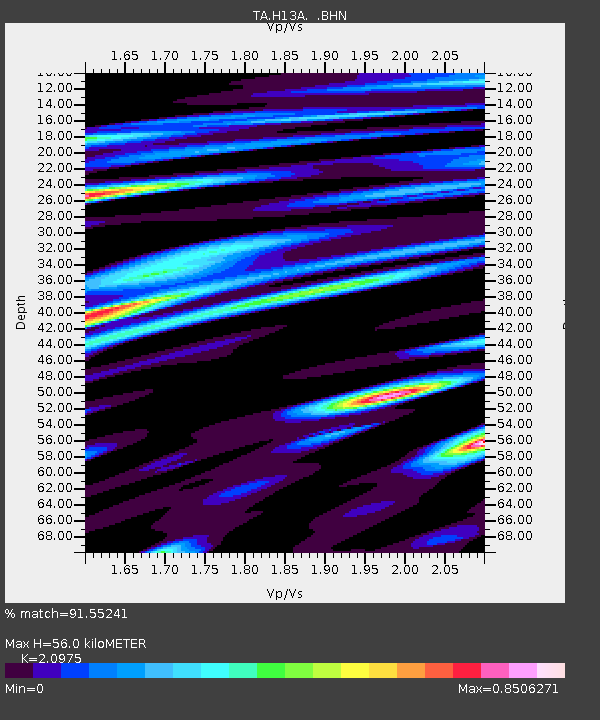
| Estimated Moho Depth: |
56.0 km |
| Estimated Crust Vp/Vs: |
2.10 |
| Assumed Crust Vp: |
6.577 km/s |
| Estimated Crust Vs: |
3.136 km/s |
| Estimated Crust Poisson's Ratio: |
0.35 |
|
| Radial Match: |
91.55241 % |
| Radial Bump: |
400 |
| Transverse Match: |
83.506454 % |
| Transverse Bump: |
400 |
| SOD ConfigId: |
2564 |
| Insert Time: |
2010-03-06 14:06:36.354 +0000 |
| GWidth: |
2.5 |
| Max Bumps: |
400 |
| Tol: |
0.001 |
|
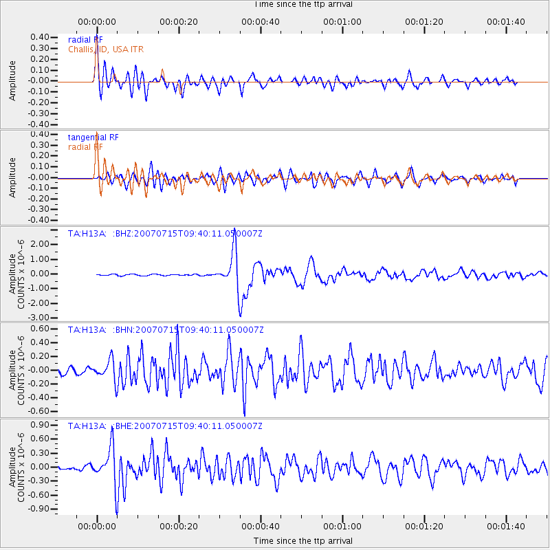
Signal To Noise
| Channel | StoN | STA | LTA |
| TA:H13A: :BHN:20070715T09:40:11.050007Z | 3.6006427 | 1.5195035E-7 | 4.2200895E-8 |
| TA:H13A: :BHE:20070715T09:40:11.050007Z | 12.869742 | 4.0495632E-7 | 3.146577E-8 |
| TA:H13A: :BHZ:20070715T09:40:11.050007Z | 28.938934 | 1.2882994E-6 | 4.4517858E-8 |
| Arrivals |
| Ps | 9.5 SECOND |
| PpPs | 26 SECOND |
| PsPs/PpSs | 35 SECOND |


