You are here: Home > Network List > TA - USArray Transportable Network (new EarthScope stations) Stations List
> Station H13A Challis, ID, USA > Earthquake Result Viewer
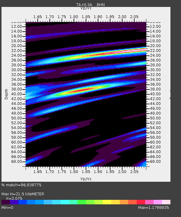
H13A Challis, ID, USA - Earthquake Result Viewer
| Earthquake location: |
East Of Kuril Islands |
| Earthquake latitude/longitude: |
46.2/154.5 |
| Earthquake time(UTC): |
2007/01/13 (013) 04:23:21 GMT |
| Earthquake Depth: |
10 km |
| Earthquake Magnitude: |
7.3 MB, 8.2 MS, 8.1 MW, 7.9 MW |
| Earthquake Catalog/Contributor: |
WHDF/NEIC |
|
| Network: |
TA USArray Transportable Network (new EarthScope stations) |
| Station: |
H13A Challis, ID, USA |
| Lat/Lon: |
44.56 N/114.25 W |
| Elevation: |
1563 m |
|
| Distance: |
60.5 deg |
| Az: |
55.221 deg |
| Baz: |
307.111 deg |
| Ray Param: |
0.061512083 |
| Estimated Moho Depth: |
21.5 km |
| Estimated Crust Vp/Vs: |
2.08 |
| Assumed Crust Vp: |
6.577 km/s |
| Estimated Crust Vs: |
3.17 km/s |
| Estimated Crust Poisson's Ratio: |
0.35 |
|
| Radial Match: |
96.839775 % |
| Radial Bump: |
400 |
| Transverse Match: |
87.63616 % |
| Transverse Bump: |
400 |
| SOD ConfigId: |
2564 |
| Insert Time: |
2010-03-06 14:07:00.817 +0000 |
| GWidth: |
2.5 |
| Max Bumps: |
400 |
| Tol: |
0.001 |
|

Signal To Noise
| Channel | StoN | STA | LTA |
| TA:H13A: :BHN:20070113T04:32:59.899014Z | 9.248577 | 7.0854E-7 | 7.6610704E-8 |
| TA:H13A: :BHE:20070113T04:32:59.899014Z | 9.802299 | 1.0271045E-6 | 1.04782E-7 |
| TA:H13A: :BHZ:20070113T04:32:59.899014Z | 13.434818 | 2.5052682E-6 | 1.8647577E-7 |
| Arrivals |
| Ps | 3.7 SECOND |
| PpPs | 9.6 SECOND |
| PsPs/PpSs | 13 SECOND |


