You are here: Home > Network List > CI - Caltech Regional Seismic Network Stations List
> Station SWS Sam W. Stewart, Westmorland, CA, USA > Earthquake Result Viewer
SWS Sam W. Stewart, Westmorland, CA, USA - Earthquake Result Viewer

| Earthquake location: |
Costa Rica |
| Earthquake latitude/longitude: |
8.8/-83.2 |
| Earthquake time(UTC): |
2018/08/17 (229) 23:22:24 GMT |
| Earthquake Depth: |
15 km |
| Earthquake Magnitude: |
6.1 Mww |
| Earthquake Catalog/Contributor: |
NEIC PDE/us |
|
| Network: |
CI Caltech Regional Seismic Network |
| Station: |
SWS Sam W. Stewart, Westmorland, CA, USA |
| Lat/Lon: |
32.94 N/115.80 W |
| Elevation: |
140 m |
|
| Distance: |
38.6 deg |
| Az: |
313.319 deg |
| Baz: |
121.215 deg |
| Ray Param: |
0.0754745 |
| Estimated Moho Depth: |
17.5 km |
| Estimated Crust Vp/Vs: |
1.79 |
| Assumed Crust Vp: |
6.155 km/s |
| Estimated Crust Vs: |
3.448 km/s |
| Estimated Crust Poisson's Ratio: |
0.27 |
|
| Radial Match: |
92.8657 % |
| Radial Bump: |
360 |
| Transverse Match: |
85.11672 % |
| Transverse Bump: |
395 |
| SOD ConfigId: |
13570011 |
| Insert Time: |
2019-04-30 20:31:01.146 +0000 |
| GWidth: |
2.5 |
| Max Bumps: |
400 |
| Tol: |
0.001 |
|
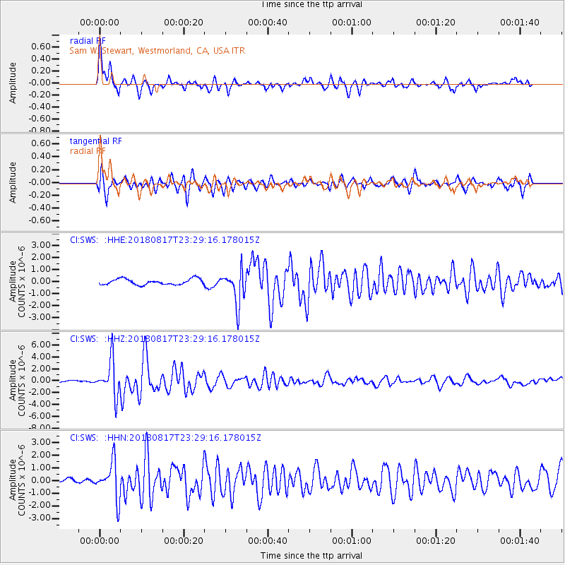
Signal To Noise
| Channel | StoN | STA | LTA |
| CI:SWS: :HHZ:20180817T23:29:16.178015Z | 20.95736 | 3.05991E-6 | 1.4600646E-7 |
| CI:SWS: :HHN:20180817T23:29:16.178015Z | 8.485079 | 1.4812167E-6 | 1.7456723E-7 |
| CI:SWS: :HHE:20180817T23:29:16.178015Z | 6.013136 | 1.4444952E-6 | 2.4022327E-7 |
| Arrivals |
| Ps | 2.4 SECOND |
| PpPs | 7.4 SECOND |
| PsPs/PpSs | 9.8 SECOND |


